
Make a donation
Gear up for your next adventure:
As an Amazon Associate, this site earns from qualifying purchases at no extra cost to you.
Fervença topographic map
Click on the map to display elevation.
Make a donation
Gear up for your next adventure:
As an Amazon Associate, this site earns from qualifying purchases at no extra cost to you.
About this map
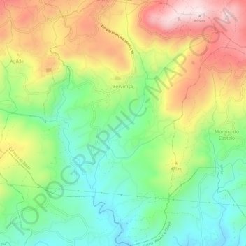
Name: Fervença topographic map, elevation, terrain.
Location: Fervença, Celorico de Basto, Braga, Portugal (41.32935 -8.11745 41.37311 -8.06243)
Average elevation: 1,283 ft
Minimum elevation: 591 ft
Maximum elevation: 2,241 ft
Make a donation
Gear up for your next adventure:
As an Amazon Associate, this site earns from qualifying purchases at no extra cost to you.
Other topographic maps
Click on a map to view its topography, its elevation and its terrain.
Borba de Montanha
Portugal > Braga > Celorico de Basto > Borba de Montanha
Average elevation: 2,113 ft
Make a donation
Gear up for your next adventure:
As an Amazon Associate, this site earns from qualifying purchases at no extra cost to you.
Make a donation
Gear up for your next adventure:
As an Amazon Associate, this site earns from qualifying purchases at no extra cost to you.