Geolocate

Hartline topographic map

Click on the map to display elevation.

About this map

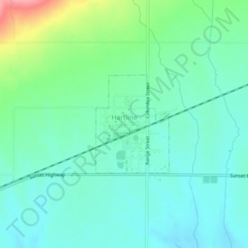
Name: Hartline topographic map, elevation, terrain.

Location: Hartline, Grant County, Washington, United States (47.68492 -119.11392 47.69561 -119.10208)

Average elevation: 1,923 ft

Minimum elevation: 1,841 ft

Maximum elevation: 2,169 ft

Grant County trails, hiking, mountain biking, running and outdoor activities

Other topographic maps

Click on a map to view its topography, its elevation and its terrain.

Stratford

United States > Washington > Grant County

Average elevation: 1,404 ft

Schwana

United States > Washington > Grant County

Average elevation: 705 ft

Lake Access Road

United States > Washington > Grant County

Average elevation: 2,297 ft

Carpenter Park

United States > Washington > Grant County > Moses Lake

Average elevation: 1,060 ft

Moses Lake

United States > Washington > Grant County > Moses Lake > Moses Lake

Average elevation: 1,122 ft

Beverly

United States > Washington > Grant County

Average elevation: 636 ft

McDonald

United States > Washington > Grant County > McDonald

Average elevation: 1,168 ft

Gear up for your next adventure:

💧Water Filtration Bottles - Safely drink from streams and lakes while exploring
🕶️Glacier Sunglasses - Side shields to protect eyes from high-altitude snow glare
🧢Sun Protection Hats - Wide-brimmed and UPF-rated hats for high-altitude sun safety
🕶️GPS Smartphone Mount - Secure mount for phone navigation
🪑Portable Camp Table - Compact table for campsite meals

As an Amazon Associate, this site earns from qualifying purchases at no extra cost to you.