Geolocate

Keller topographic map

Click on the map to display elevation.

About this map

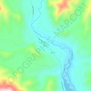
Name: Keller topographic map, elevation, terrain.

Location: Keller, Ferry County, Washington, 99140, United States (48.05720 -118.70377 48.09720 -118.66377)

Average elevation: 1,759 ft

Minimum elevation: 1,273 ft

Maximum elevation: 3,196 ft

Ferry County trails, hiking, mountain biking, running and outdoor activities

Other topographic maps

Click on a map to view its topography, its elevation and its terrain.

Inchelium

United States > Washington > Ferry County

Average elevation: 2,096 ft

Keller

United States > Washington > Ferry County > Keller

Average elevation: 2,218 ft

Ferry Lake

United States > Washington > Ferry County

Average elevation: 3,432 ft

Wiseman Island

United States > Washington > Ferry County > Pollard

Average elevation: 2,549 ft

Gear up for your next adventure:

📡Handheld GPS Device - Reliable handheld GPS for outdoor navigation
GPS Sports Watch - GPS watch for running, hiking and training
🛡️Insect Repellent - Protection against bugs during outdoor activities
🛠️Outdoor Gear Repair Kit - Essential tools to fix gear on the trail
🪶Thermal Camp Blanket - Extra warmth for cold nights

As an Amazon Associate, this site earns from qualifying purchases at no extra cost to you.