
Make a donation
Gear up for your next adventure:
As an Amazon Associate, this site earns from qualifying purchases at no extra cost to you.
Chapin topographic map
Click on the map to display elevation.
Make a donation
Gear up for your next adventure:
As an Amazon Associate, this site earns from qualifying purchases at no extra cost to you.
About this map
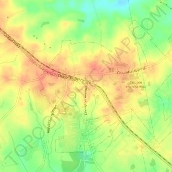
Name: Chapin topographic map, elevation, terrain.
Location: Chapin, Lexington County, South Carolina, United States (34.15236 -81.36033 34.17803 -81.32189)
Average elevation: 436 ft
Minimum elevation: 338 ft
Maximum elevation: 502 ft
Lexington County trails, hiking, mountain biking, running and outdoor activities
Make a donation
Gear up for your next adventure:
As an Amazon Associate, this site earns from qualifying purchases at no extra cost to you.
Other topographic maps
Click on a map to view its topography, its elevation and its terrain.
Coventry Woods
United States > South Carolina > Lexington County > Lexington
Average elevation: 351 ft
Make a donation
Gear up for your next adventure:
As an Amazon Associate, this site earns from qualifying purchases at no extra cost to you.
Leesville
United States > South Carolina > Lexington County > Batesburg-Leesville
Average elevation: 623 ft
Laurel Meadows
United States > South Carolina > Lexington County > Lexington
Average elevation: 325 ft
Apollo Gardens
United States > South Carolina > Lexington County > Pine Ridge
Average elevation: 220 ft
Make a donation
Gear up for your next adventure:
As an Amazon Associate, this site earns from qualifying purchases at no extra cost to you.
Leesville
United States > South Carolina > Lexington County > Batesburg-Leesville > Leesville
Average elevation: 623 ft
Make a donation
Gear up for your next adventure:
As an Amazon Associate, this site earns from qualifying purchases at no extra cost to you.
Make a donation
Gear up for your next adventure:
As an Amazon Associate, this site earns from qualifying purchases at no extra cost to you.