Geolocate

Byron topographic map

Click on the map to display elevation.

About this map

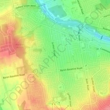
Name: Byron topographic map, elevation, terrain.

Location: Byron, London, Ontario, N6K 1E1, Canada (42.94618 -81.35106 42.96618 -81.33106)

Average elevation: 866 ft

Minimum elevation: 732 ft

Maximum elevation: 1,001 ft

Other topographic maps

Click on a map to view its topography, its elevation and its terrain.

St. Lawrence Park

Canada > Ontario > London

Average elevation: 899 ft

Coves Elmwood Gateway Park

Canada > Ontario > London

Average elevation: 817 ft

Gibbons Park

Canada > Ontario > London

Average elevation: 814 ft

Gear up for your next adventure:

🪶Survival Guide Book - Expert advice for emergency preparedness
🚑Emergency Bivvies - Heat-reflective sleeping bags for survival situations
🔭Compact Binoculars - HD vision for scouting terrain and identifying distant landmarks
🔪Outdoor Multitools - Essential survival tools for gear repair and field use
🧭Map Reading Tools - Tools and kits for map navigation

As an Amazon Associate, this site earns from qualifying purchases at no extra cost to you.