
Make a donation
Gear up for your next adventure:
As an Amazon Associate, this site earns from qualifying purchases at no extra cost to you.
Bellsbank topographic map
Click on the map to display elevation.
Make a donation
Gear up for your next adventure:
As an Amazon Associate, this site earns from qualifying purchases at no extra cost to you.
About this map
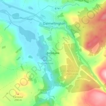
Name: Bellsbank topographic map, elevation, terrain.
Location: Bellsbank, East Ayrshire, Scotland, KA6 7TJ, United Kingdom (55.29207 -4.41770 55.33207 -4.37770)
Average elevation: 748 ft
Minimum elevation: 518 ft
Maximum elevation: 1,191 ft
Make a donation
Gear up for your next adventure:
As an Amazon Associate, this site earns from qualifying purchases at no extra cost to you.
Other topographic maps
Click on a map to view its topography, its elevation and its terrain.
Make a donation
Gear up for your next adventure:
As an Amazon Associate, this site earns from qualifying purchases at no extra cost to you.
Make a donation
Gear up for your next adventure:
As an Amazon Associate, this site earns from qualifying purchases at no extra cost to you.
South Dean Plantation
United Kingdom > Scotland > East Ayrshire > Kilmarnock
Average elevation: 210 ft