
Make a donation
Gear up for your next adventure:
As an Amazon Associate, this site earns from qualifying purchases at no extra cost to you.
Lake Spaulding topographic map
Click on the map to display elevation.
Make a donation
Gear up for your next adventure:
As an Amazon Associate, this site earns from qualifying purchases at no extra cost to you.
About this map
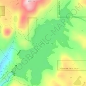
Name: Lake Spaulding topographic map, elevation, terrain.
Location: Lake Spaulding, Nevada County, California, United States (39.32259 -120.64416 39.35189 -120.61452)
Average elevation: 5,154 ft
Minimum elevation: 4,557 ft
Maximum elevation: 5,971 ft
Nevada County trails, hiking, mountain biking, running and outdoor activities
Make a donation
Gear up for your next adventure:
As an Amazon Associate, this site earns from qualifying purchases at no extra cost to you.
Other topographic maps
Click on a map to view its topography, its elevation and its terrain.
Grass Valley
United States > California > Nevada County > Grass Valley
Grass Valley is a city in Nevada County, California, United States. Situated at roughly 2,500 feet (760 m) elevation in the western foothills of the Sierra Nevada mountain range, this historic northern Gold Country city is 57 miles (92 km) by car from the state capitol in Sacramento, 64 miles (103 km) from…
Average elevation: 2,543 ft
Make a donation
Gear up for your next adventure:
As an Amazon Associate, this site earns from qualifying purchases at no extra cost to you.
Make a donation
Gear up for your next adventure:
As an Amazon Associate, this site earns from qualifying purchases at no extra cost to you.
Lake of the Pines
United States > California > Nevada County
Lake of the Pines is commonly associated with a gated residential community which surrounds a reservoir, also named Lake of the Pines. The reservoir was created by damming Magnolia Creek, in the Bear River watershed, and it has a maximum elevation of 459 m (1507 ft). The gated community contains a golf course…
Average elevation: 1,581 ft
Make a donation
Gear up for your next adventure:
As an Amazon Associate, this site earns from qualifying purchases at no extra cost to you.
Alta Sierra
United States > California > Nevada County
Alta Sierra was laid out by property developers in the 1960s. Alta Sierra is a golf course community, with homes built around the Alta Sierra Country Club, a semi-private 18 hole course built in 1964. The community has a member-owned airport with a 2800-foot runway. The community is located just east of…
Average elevation: 1,978 ft