
Blaauwberg Hill topographic map
Interactive map
Click on the map to display elevation.
About this map
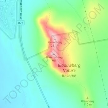
Name: Blaauwberg Hill topographic map, elevation, terrain.
Average elevation: 236 ft
Minimum elevation: 23 ft
Maximum elevation: 748 ft
Other topographic maps
Click on a map to view its topography, its elevation and its terrain.
Cape Town
South Africa > Western Cape > City of Cape Town
Cape Town, City of Cape Town, Western Cape, 8001, South Africa
Average elevation: 174 ft
Durbanville
South Africa > Western Cape > City of Cape Town
Durbanville, City of Cape Town, Western Cape, 7550, South Africa
Average elevation: 515 ft
Khayelitsha
South Africa > Western Cape > City of Cape Town
Khayelitsha, City of Cape Town, Western Cape, 7784, South Africa
Average elevation: 85 ft
Table Mountain
South Africa > Western Cape > City of Cape Town > Cape Town
Table Mountain, Cape Town Ward 54, Cape Town, City of Cape Town, Western Cape, 8040, South Africa
Average elevation: 1,913 ft
De Goede Hoop
South Africa > Western Cape > City of Cape Town > Noordhoek
De Goede Hoop, Cape Town Ward 69, Noordhoek, City of Cape Town, Western Cape, 7985, South Africa
Average elevation: 663 ft
Blaauwberg Nature Reserve
South Africa > Western Cape > City of Cape Town > Melkbosstrand
Blaauwberg Nature Reserve, Amble Way, Cape Town Ward 23, Melkbosstrand, City of Cape Town, Western Cape, 7433, South Africa
Average elevation: 151 ft
Hout Bay
South Africa > Western Cape > City of Cape Town > Hout Bay
Hout Bay, City of Cape Town, Western Cape, South Africa
Average elevation: 633 ft
Llandudno Beach
South Africa > Western Cape > City of Cape Town > Cape Town > Llandudno
Llandudno Beach, Llandudno, Cape Town Ward 74, Cape Town, City of Cape Town, Western Cape, South Africa
Average elevation: 354 ft
Bellville
South Africa > Western Cape > City of Cape Town
Bellville, City of Cape Town, Western Cape, South Africa
Average elevation: 377 ft
Cape Town Ward 69
South Africa > Western Cape > City of Cape Town > Noordhoek
Cape Town Ward 69, Noordhoek, City of Cape Town, Western Cape, South Africa
Average elevation: 449 ft
Cape Town Ward 11
South Africa > Western Cape > City of Cape Town > Kuilsrivier
Cape Town Ward 11, Kuilsrivier, City of Cape Town, Western Cape, 7580, South Africa
Average elevation: 190 ft
Cape Town Ward 98
South Africa > Western Cape > City of Cape Town > Khayelitsha
Cape Town Ward 98, Khayelitsha, City of Cape Town, Western Cape, 7784, South Africa
Average elevation: 89 ft
Mitchells Plain
South Africa > Western Cape > City of Cape Town
Mitchells Plain, City of Cape Town, Western Cape, 7785, South Africa
Average elevation: 79 ft
Trafalgar Park
South Africa > Western Cape > City of Cape Town > Cape Town
Trafalgar Park, Cape Town Ward 115, Cape Town, City of Cape Town, Western Cape, 7925, South Africa
Average elevation: 164 ft
Lourens River
South Africa > Western Cape > City of Cape Town
Lourens River, Cape Town Ward 84, City of Cape Town, Western Cape, South Africa
Average elevation: 1,135 ft
Misty Cliffs
South Africa > Western Cape > City of Cape Town
Misty Cliffs, Cape Town Ward 61, City of Cape Town, Western Cape, South Africa
Average elevation: 443 ft
Kuils River
South Africa > Western Cape > City of Cape Town > Durbanville
Kuils River, Tara, Cape Town Ward 21, Durbanville, City of Cape Town, Western Cape, 7550, South Africa
Average elevation: 400 ft
Zandvlei Estuary Nature Reserve
South Africa > Western Cape > City of Cape Town
Zandvlei Estuary Nature Reserve, Spoon Street, Cape Town Ward 64, City of Cape Town, Western Cape, 7945, South Africa
Average elevation: 135 ft
Simon's Town
South Africa > Western Cape > City of Cape Town
Simon's Town, City of Cape Town, Western Cape, 7995, South Africa
Average elevation: 440 ft
Fish Hoek
South Africa > Western Cape > City of Cape Town
Fish Hoek, City of Cape Town, Western Cape, South Africa
Average elevation: 262 ft
Kraaifontein
South Africa > Western Cape > City of Cape Town
Kraaifontein, City of Cape Town, Western Cape, 7561, South Africa
Average elevation: 374 ft
Green Point Park
South Africa > Western Cape > City of Cape Town > Cape Town
Green Point Park, Green Point, Cape Town, City of Cape Town, Western Cape, 8005, South Africa
Average elevation: 98 ft
Kanonkop
South Africa > Western Cape > City of Cape Town > Bellville
Kanonkop, Bellville, City of Cape Town, Western Cape, 7551, South Africa
Average elevation: 906 ft
Table Mountain (Maclear's beacon)
South Africa > Western Cape > City of Cape Town > Cape Town
Table Mountain (Maclear's beacon), Cape Town, City of Cape Town, Western Cape, 7735, South Africa
Average elevation: 2,215 ft
Faerie Knowe
South Africa > Western Cape > City of Cape Town > Masiphumelele
Faerie Knowe, Sunnydale, Masiphumelele, City of Cape Town, Western Cape, 7979, South Africa
Average elevation: 230 ft
Hout Bay
South Africa > Western Cape > City of Cape Town
Hout Bay, City of Cape Town, Western Cape, 7872, South Africa
Average elevation: 623 ft
Helderberg Nature Reserve
South Africa > Western Cape > City of Cape Town > Somerset West
Helderberg Nature Reserve, Somerset West, City of Cape Town, Western Cape, South Africa
Average elevation: 1,129 ft
Kuils River
South Africa > Western Cape > City of Cape Town
Kuils River, Vredekloof, Cape Town Ward 102, City of Cape Town, Western Cape, 7550, South Africa
Average elevation: 381 ft
Somerset West
South Africa > Western Cape > City of Cape Town
Somerset West, City of Cape Town, Western Cape, South Africa
Average elevation: 535 ft
Nantes
South Africa > Western Cape > City of Cape Town > Cape Town
Nantes, Silvertown, Cape Town, City of Cape Town, Western Cape, South Africa
Average elevation: 46 ft
Silvermist Estate
South Africa > Western Cape > City of Cape Town > Cape Town
Silvermist Estate, Cape Town Ward 74, Cape Town, City of Cape Town, Western Cape, 7848, South Africa
Average elevation: 892 ft
Atlantis
South Africa > Western Cape > City of Cape Town
Atlantis, City of Cape Town, Western Cape, South Africa
Average elevation: 531 ft
Blinkwater
South Africa > Western Cape > City of Cape Town > Cape Town
Blinkwater, Bakoven, Cape Town Ward 54, Cape Town, City of Cape Town, Western Cape, 8005, South Africa
Average elevation: 961 ft
Cape Peninsula
South Africa > Western Cape > City of Cape Town > Simon's Town
Cape Peninsula, Cape Town Ward 61, Simon's Town, City of Cape Town, Western Cape, 7995, South Africa
Average elevation: 620 ft
Newlands Forest
South Africa > Western Cape > City of Cape Town > Cape Town
Newlands Forest, Cape Town, City of Cape Town, Western Cape, South Africa
Average elevation: 1,086 ft
Elsieskraal River
South Africa > Western Cape > City of Cape Town > Cape Town
Elsieskraal River, Pinelands, Cape Town Ward 53, Cape Town, City of Cape Town, Western Cape, 7450, South Africa
Average elevation: 36 ft
Mount Rhodes
South Africa > Western Cape > City of Cape Town > Hout Bay
Mount Rhodes, Cape Town Ward 74, Hout Bay, City of Cape Town, Western Cape, 7872, South Africa
Average elevation: 518 ft
Elsiesriver
South Africa > Western Cape > City of Cape Town
Elsiesriver, City of Cape Town, Western Cape, 7493, South Africa
Average elevation: 141 ft
Rietvlei Wetland Reserve
South Africa > Western Cape > City of Cape Town > Cape Town
Rietvlei Wetland Reserve, Otto Du Plessis Drive, Sunset Beach, Cape Town Ward 113, Cape Town, City of Cape Town, Western Cape, 2251, South Africa
Average elevation: 16 ft
Milnerton
South Africa > Western Cape > City of Cape Town
Milnerton, City of Cape Town, Western Cape, 2251, South Africa
Average elevation: 33 ft
Blue Downs
South Africa > Western Cape > City of Cape Town
Blue Downs, City of Cape Town, Western Cape, 7103, South Africa
Average elevation: 135 ft
Strand
South Africa > Western Cape > City of Cape Town
Strand, City of Cape Town, Western Cape, 7136, South Africa
Average elevation: 72 ft
Castle of Good Hope
South Africa > Western Cape > City of Cape Town > Cape Town
Castle of Good Hope, Oranje Bastion, Foreshore, Cape Town Ward 115, Cape Town, City of Cape Town, Western Cape, 8001, South Africa
Average elevation: 125 ft
Cape Point
South Africa > Western Cape > City of Cape Town
Cape Point, Cape Town Ward 61, City of Cape Town, Western Cape, South Africa
Average elevation: 26 ft
Parow
South Africa > Western Cape > City of Cape Town
Parow, City of Cape Town, Western Cape, 7500, South Africa
Average elevation: 240 ft
Robben Island
South Africa > Western Cape > City of Cape Town > Robben Island Village
Robben Island, Robben Island Village, City of Cape Town, Western Cape, South Africa
Average elevation: 16 ft
Bredell dam
South Africa > Western Cape > City of Cape Town > Somerset West
Bredell dam, Bellaire, Cape Town Ward 15, Somerset West, City of Cape Town, Western Cape, South Africa
Average elevation: 371 ft
Witzands Aquifer Nature Reserve
South Africa > Western Cape > City of Cape Town > Atlantis
Witzands Aquifer Nature Reserve, 1, Dassenberg Drive, Cape Town Ward 32, Atlantis, City of Cape Town, Western Cape, South Africa
Average elevation: 272 ft
Sir Lowry's Pass
South Africa > Western Cape > City of Cape Town
Sir Lowry's Pass, City of Cape Town, Western Cape, 7135, South Africa
Average elevation: 492 ft
Tygerberg
South Africa > Western Cape > City of Cape Town > Bellville
Tygerberg, Bellville, City of Cape Town, Western Cape, 7500, South Africa
Average elevation: 787 ft