
Make a donation
Gear up for your next adventure:
As an Amazon Associate, this site earns from qualifying purchases at no extra cost to you.
Lanesborough topographic map
Click on the map to display elevation.
Make a donation
Gear up for your next adventure:
As an Amazon Associate, this site earns from qualifying purchases at no extra cost to you.
About this map
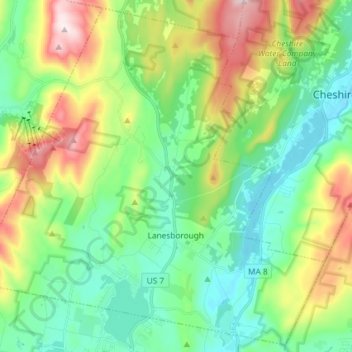
Name: Lanesborough topographic map, elevation, terrain.
Average elevation: 1,476 ft
Minimum elevation: 955 ft
Maximum elevation: 2,585 ft
Berkshire County trails, hiking, mountain biking, running and outdoor activities
Make a donation
Gear up for your next adventure:
As an Amazon Associate, this site earns from qualifying purchases at no extra cost to you.
Other topographic maps
Click on a map to view its topography, its elevation and its terrain.
Taconic Mountain Wildlife Management Area
United States > Massachusetts > Berkshire County > Williamstown
Average elevation: 1,995 ft
June Mountain
United States > Massachusetts > Berkshire County > Sheffield
Average elevation: 1,115 ft
Lake Averic
United States > Massachusetts > Berkshire County > Stockbridge > Interlaken
Average elevation: 1,070 ft
Make a donation
Gear up for your next adventure:
As an Amazon Associate, this site earns from qualifying purchases at no extra cost to you.
Camp Merrill
United States > Massachusetts > Berkshire County > Pittsfield
Average elevation: 1,158 ft
Braytonville
United States > Massachusetts > Berkshire County > North Adams
Average elevation: 1,027 ft
Berkshire South
United States > Massachusetts > Berkshire County > Great Barrington
Average elevation: 873 ft
Make a donation
Gear up for your next adventure:
As an Amazon Associate, this site earns from qualifying purchases at no extra cost to you.
Root Orchards
United States > Massachusetts > Berkshire County > Great Barrington > Housatonic > Risingdale
Average elevation: 912 ft
Natural Bridge State Park
United States > Massachusetts > Berkshire County > North Adams
Average elevation: 1,043 ft
Make a donation
Gear up for your next adventure:
As an Amazon Associate, this site earns from qualifying purchases at no extra cost to you.
West New Boston
United States > Massachusetts > Berkshire County > Sandisfield
Average elevation: 1,168 ft
Make a donation
Gear up for your next adventure:
As an Amazon Associate, this site earns from qualifying purchases at no extra cost to you.
Indian Lake Association
United States > Massachusetts > Berkshire County > Becket
Average elevation: 1,493 ft
Tyringham Cobble
United States > Massachusetts > Berkshire County > Tyringham
Average elevation: 1,142 ft
Bonny Rigg Corners
United States > Massachusetts > Berkshire County > Becket
Average elevation: 1,476 ft
Beachwood
United States > Massachusetts > Berkshire County > Stockbridge > Beachwood
Average elevation: 1,040 ft
Make a donation
Gear up for your next adventure:
As an Amazon Associate, this site earns from qualifying purchases at no extra cost to you.
South Mountain
United States > Massachusetts > Berkshire County > Pittsfield
Average elevation: 1,106 ft
North Adams
United States > Massachusetts > Berkshire County > North Adams > North Adams
Average elevation: 1,362 ft
Make a donation
Gear up for your next adventure:
As an Amazon Associate, this site earns from qualifying purchases at no extra cost to you.