
Make a donation
Gear up for your next adventure:
As an Amazon Associate, this site earns from qualifying purchases at no extra cost to you.
Chuckanut Mountain topographic map
Click on the map to display elevation.
Make a donation
Gear up for your next adventure:
As an Amazon Associate, this site earns from qualifying purchases at no extra cost to you.
About this map
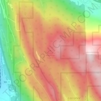
Name: Chuckanut Mountain topographic map, elevation, terrain.
Average elevation: 1,079 ft
Minimum elevation: 49 ft
Maximum elevation: 1,834 ft
Whatcom County trails, hiking, mountain biking, running and outdoor activities
Make a donation
Gear up for your next adventure:
As an Amazon Associate, this site earns from qualifying purchases at no extra cost to you.
Other topographic maps
Click on a map to view its topography, its elevation and its terrain.
Ross Lake
United States > Washington > Whatcom County
Ross Lake is a large reservoir in the North Cascade mountains of northern Washington state, United States, and southwestern British Columbia, Canada. The lake runs approximately north–south, is 23 miles (37 km) long, up to 1.5 miles (2.5 km) wide, and the full reservoir elevation is 1,604 feet above sea…
Average elevation: 4,311 ft
Make a donation
Gear up for your next adventure:
As an Amazon Associate, this site earns from qualifying purchases at no extra cost to you.