
Sudden Valley topographic map
Click on the map to display elevation.
About this map
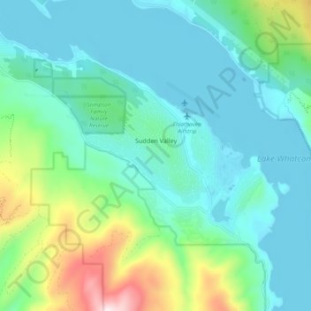
Name: Sudden Valley topographic map, elevation, terrain.
Location: Sudden Valley, Whatcom County, Washington, United States (48.69076 -122.39572 48.74909 -122.30380)
Average elevation: 784 ft
Minimum elevation: 285 ft
Maximum elevation: 2,625 ft
Whatcom County trails, hiking, mountain biking, running and outdoor activities
Other topographic maps
Click on a map to view its topography, its elevation and its terrain.
Bellingham
United States > Washington > Whatcom County > Bellingham
According to the United States Census Bureau, the city has a total area of 28.90 square miles (74.85 km2), of which, 27.08 square miles (70.14 km2) is land and 1.82 square miles (4.71 km2) is water. The lowest elevations are at sea level along the waterfront. Alabama Hill is one of the higher points in the…
Average elevation: 423 ft