
Make a donation
Gear up for your next adventure:
As an Amazon Associate, this site earns from qualifying purchases at no extra cost to you.
Justiceburg topographic map
Click on the map to display elevation.
Make a donation
Gear up for your next adventure:
As an Amazon Associate, this site earns from qualifying purchases at no extra cost to you.
About this map
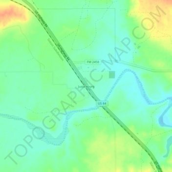
Name: Justiceburg topographic map, elevation, terrain.
Location: Justiceburg, Garza County, Texas, 79330, United States (33.02266 -101.22299 33.06266 -101.18299)
Average elevation: 2,267 ft
Minimum elevation: 2,221 ft
Maximum elevation: 2,349 ft
Garza County trails, hiking, mountain biking, running and outdoor activities
Make a donation
Gear up for your next adventure:
As an Amazon Associate, this site earns from qualifying purchases at no extra cost to you.
Other topographic maps
Click on a map to view its topography, its elevation and its terrain.
Lake Alan Henry
United States > Texas > Garza County
Lake Alan Henry is located on the Double Mountain Fork Brazos River in West Texas. South of Lubbock and east of Justiceburg, the lake extends 11 mi (18 km) and has over 56 mi (90 km) of shoreline. Its elevation is 1,000 ft (300 m) lower than the city of Lubbock. Lake Alan Henry has a maximum depth of 100 ft…
Average elevation: 2,320 ft