
Make a donation
Gear up for your next adventure:
As an Amazon Associate, this site earns from qualifying purchases at no extra cost to you.
Lake Alan Henry topographic map
Click on the map to display elevation.
Make a donation
Gear up for your next adventure:
As an Amazon Associate, this site earns from qualifying purchases at no extra cost to you.
Lake Alan Henry
Lake Alan Henry is located on the Double Mountain Fork Brazos River in West Texas. South of Lubbock and east of Justiceburg, the lake extends 11 mi (18 km) and has over 56 mi (90 km) of shoreline. Its elevation is 1,000 ft (300 m) lower than the city of Lubbock. Lake Alan Henry has a maximum depth of 100 ft (30 m) with an average depth of 40 ft (12 m), and the water is typically murky-to-clear with a visibility depth of one to four feet. Lake water levels fluctuate moderately between two and four feet per year. Vegetation of the lake mainly consists of flooded trees.
Make a donation
Gear up for your next adventure:
As an Amazon Associate, this site earns from qualifying purchases at no extra cost to you.
About this map
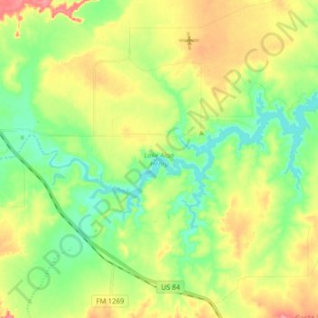
Name: Lake Alan Henry topographic map, elevation, terrain.
Location: Lake Alan Henry, Garza County, Texas, United States (33.00809 -101.18305 33.06464 -101.02857)
Average elevation: 2,320 ft
Minimum elevation: 2,201 ft
Maximum elevation: 2,497 ft
Garza County trails, hiking, mountain biking, running and outdoor activities
Make a donation
Gear up for your next adventure:
As an Amazon Associate, this site earns from qualifying purchases at no extra cost to you.
Other topographic maps
Click on a map to view its topography, its elevation and its terrain.