Geolocate

Semeling topographic map

Click on the map to display elevation.

About this map

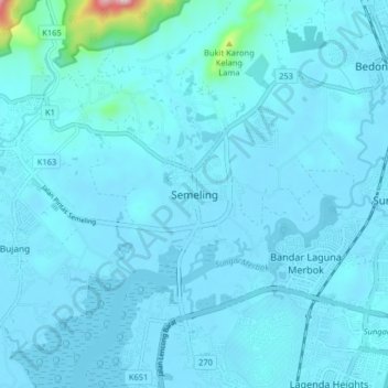
Name: Semeling topographic map, elevation, terrain.

Location: Semeling, Kuala Muda, Kedah, 08100, Malaysia (5.66103 100.43206 5.74103 100.51206)

Average elevation: 82 ft

Minimum elevation: -3 ft

Maximum elevation: 1,496 ft

Other topographic maps

Click on a map to view its topography, its elevation and its terrain.

Melaka River

Malaysia > Kedah > Kampung Padang Gaong

Average elevation: 59 ft

Sungai Lalang

Malaysia > Kedah > Sungai Lalang

Average elevation: 39 ft

Sungai Kupang

Malaysia > Kedah > Kupang

Average elevation: 233 ft

Kota Setar

Malaysia > Kedah

Average elevation: 16 ft

Sungai Sedim

Malaysia > Kedah

Average elevation: 82 ft

Kuala Muda

Malaysia > Kedah

Average elevation: 161 ft

Sungai Sedim

Malaysia > Kedah > Kampung Badang

Average elevation: 266 ft

Kerian River

Malaysia > Kedah

Average elevation: 10 ft

Gear up for your next adventure:

🗺️NatGeo Topo Maps - High-quality waterproof printed topographic maps of US Parks
🥄Camping Utensil Set - Lightweight utensils for outdoor meals
🎒Outdoor Daypacks - Lightweight backpacks designed for carrying maps and essential gear
📶Satellite Messenger - Communication device off‑grid
📌Outdoor GPS Map App - Apps and devices for digital topographic navigation

As an Amazon Associate, this site earns from qualifying purchases at no extra cost to you.