
Make a donation
Gear up for your next adventure:
As an Amazon Associate, this site earns from qualifying purchases at no extra cost to you.
Wallburg topographic map
Click on the map to display elevation.
Make a donation
Gear up for your next adventure:
As an Amazon Associate, this site earns from qualifying purchases at no extra cost to you.
Wallburg
Wallburg is located in northeastern Davidson County at 36°0′36″N 80°8′22″W / 36.01000°N 80.13944°W / 36.01000; -80.13944. It is bordered to the north by Forsyth County. The town is largely along North Carolina Highway 109, about 10 miles (16 km) southeast of Winston-Salem and the same distance northwest of High Point, between the intersections with Gumtree Road and Shady Grove Church Road, at an elevation of 920 feet (280 m) above sea level. Other nearby municipalities include Kernersville to the northeast, Thomasville to the south, and Midway to the southwest. Wallburg is located in the Wallburg Elementary, Oak Grove Middle School, and Ledford Senior High school districts. In 2017, the Wallburg high school district will be changed to the Oak Grove High School district, which will be located across the street from Oak Grove Middle School.
Make a donation
Gear up for your next adventure:
As an Amazon Associate, this site earns from qualifying purchases at no extra cost to you.
About this map
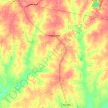
Name: Wallburg topographic map, elevation, terrain.
Location: Wallburg, Davidson County, North Carolina, United States (35.97226 -80.18625 36.02673 -80.10896)
Average elevation: 856 ft
Minimum elevation: 696 ft
Maximum elevation: 955 ft
Davidson County trails, hiking, mountain biking, running and outdoor activities
Make a donation
Gear up for your next adventure:
As an Amazon Associate, this site earns from qualifying purchases at no extra cost to you.
Other topographic maps
Click on a map to view its topography, its elevation and its terrain.
Make a donation
Gear up for your next adventure:
As an Amazon Associate, this site earns from qualifying purchases at no extra cost to you.
Make a donation
Gear up for your next adventure:
As an Amazon Associate, this site earns from qualifying purchases at no extra cost to you.
Make a donation
Gear up for your next adventure:
As an Amazon Associate, this site earns from qualifying purchases at no extra cost to you.
Make a donation
Gear up for your next adventure:
As an Amazon Associate, this site earns from qualifying purchases at no extra cost to you.
Erwin Heights
United States > North Carolina > Davidson County > Thomasville
Average elevation: 833 ft
Northside
United States > North Carolina > Davidson County > Lexington > Northside
Average elevation: 774 ft
Make a donation
Gear up for your next adventure:
As an Amazon Associate, this site earns from qualifying purchases at no extra cost to you.