
Troitsk topographic map
Click on the map to display elevation.
About this map
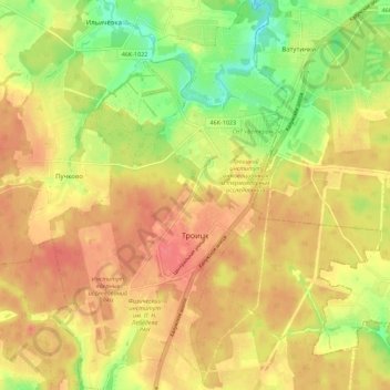
Name: Troitsk topographic map, elevation, terrain.
Location: Troitsk, Moscow, Central Federal District, Russia (55.44773 37.26002 55.51091 37.32802)
Average elevation: 584 ft
Minimum elevation: 463 ft
Maximum elevation: 669 ft
Other topographic maps
Click on a map to view its topography, its elevation and its terrain.
Moscow
Moscow is situated on the banks of the Moskva River, which flows for just over 500 km (311 mi) through the East European Plain in central Russia, not far from the natural border of the forest and forest-steppe zone. 49 bridges span the river and its canals within the city's limits. The elevation of Moscow at…
Average elevation: 522 ft