
Make a donation
Gear up for your next adventure:
As an Amazon Associate, this site earns from qualifying purchases at no extra cost to you.
Yuscarán topographic map
Click on the map to display elevation.
Make a donation
Gear up for your next adventure:
As an Amazon Associate, this site earns from qualifying purchases at no extra cost to you.
About this map
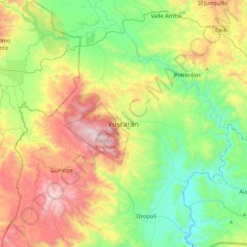
Name: Yuscarán topographic map, elevation, terrain.
Location: Yuscarán, El Paraíso, Honduras (13.78131 -87.01221 14.10131 -86.69221)
Average elevation: 2,969 ft
Minimum elevation: 1,053 ft
Maximum elevation: 6,355 ft
Make a donation
Gear up for your next adventure:
As an Amazon Associate, this site earns from qualifying purchases at no extra cost to you.
Other topographic maps
Click on a map to view its topography, its elevation and its terrain.
Danlí
Danlí is a city and a municipality in Honduras. It is currently the fourth most populated municipality in Honduras, located approximately 92 kilometers southeast of Tegucigalpa, in the Honduran department of El Paraíso known for its production of cigars and corn (maize). The city is situated at an altitude…
Average elevation: 2,848 ft