
Make a donation
Gear up for your next adventure:
As an Amazon Associate, this site earns from qualifying purchases at no extra cost to you.
Danlí topographic map
Click on the map to display elevation.
Make a donation
Gear up for your next adventure:
As an Amazon Associate, this site earns from qualifying purchases at no extra cost to you.
Danlí
Danlí is a city and a municipality in Honduras. It is currently the fourth most populated municipality in Honduras, located approximately 92 kilometers southeast of Tegucigalpa, in the Honduran department of El Paraíso known for its production of cigars and corn (maize). The city is situated at an altitude of 814 meters (2,673 feet) above sea level and has a population of 80,200 (2023 calculation) The population of the municipality (2018) is 214,566 people which is composed of 105,929 men and 108,637 women. With a population in the urban area of 85,075 people and in the rural area of 129,491 people.
Make a donation
Gear up for your next adventure:
As an Amazon Associate, this site earns from qualifying purchases at no extra cost to you.
About this map
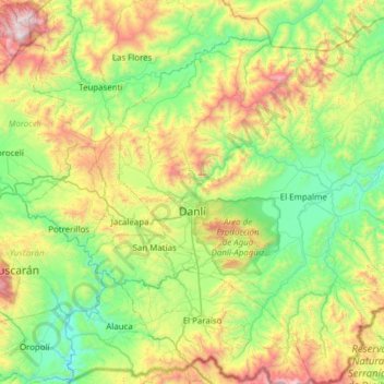
Name: Danlí topographic map, elevation, terrain.
Location: Danlí, El Paraíso, 13201, Honduras (13.76304 -86.68583 14.36062 -86.07098)
Average elevation: 2,848 ft
Minimum elevation: 1,060 ft
Maximum elevation: 7,113 ft
Make a donation
Gear up for your next adventure:
As an Amazon Associate, this site earns from qualifying purchases at no extra cost to you.
Other topographic maps
Click on a map to view its topography, its elevation and its terrain.