
Columbus topographic map
Click on the map to display elevation.
Columbus
The city lies at an elevation of 1,447 feet (441 m). It is built on the flat terrain of the Platte River valley; rolling hills rise to the north of the city.
About this map
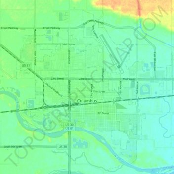
Name: Columbus topographic map, elevation, terrain.
Location: Columbus, Platte County, Nebraska, United States (41.40238 -97.39830 41.46771 -97.29998)
Average elevation: 1,450 ft
Minimum elevation: 1,414 ft
Maximum elevation: 1,539 ft
Platte County trails, hiking, mountain biking, running and outdoor activities
Other topographic maps
Click on a map to view its topography, its elevation and its terrain.
Carriage House Estates
United States > Nebraska > Platte County > Columbus
Average elevation: 1,444 ft