
Make a donation
Gear up for your next adventure:
As an Amazon Associate, this site earns from qualifying purchases at no extra cost to you.
Kanyamazane topographic map
Click on the map to display elevation.
Make a donation
Gear up for your next adventure:
As an Amazon Associate, this site earns from qualifying purchases at no extra cost to you.
About this map
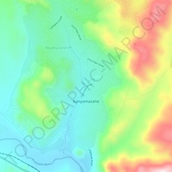
Name: Kanyamazane topographic map, elevation, terrain.
Average elevation: 2,087 ft
Minimum elevation: 1,562 ft
Maximum elevation: 3,189 ft
Make a donation
Gear up for your next adventure:
As an Amazon Associate, this site earns from qualifying purchases at no extra cost to you.
Other topographic maps
Click on a map to view its topography, its elevation and its terrain.
Kamagugu
South Africa > Mpumalanga > Ehlanzeni District Municipality > Mbombela
Average elevation: 2,247 ft
White River
South Africa > Mpumalanga > Ehlanzeni District Municipality > Mbombela
White River is located in the low altitude subtropical Lowveld climatic zone. Savannah and woodland scattered with granite outcrops form the indigenous habitat. Compared to other parts of South Africa, the climate is mild with good rainfall. Nevertheless, like the rest of South Africa, White River and its…
Average elevation: 2,959 ft
Hazyview
South Africa > Mpumalanga > Ehlanzeni District Municipality > Mbombela
Average elevation: 1,818 ft
Berg-en-Dal Rest Camp
South Africa > Mpumalanga > Ehlanzeni District Municipality > Mbombela
Average elevation: 1,309 ft
Make a donation
Gear up for your next adventure:
As an Amazon Associate, this site earns from qualifying purchases at no extra cost to you.
Kiepersol
South Africa > Mpumalanga > Ehlanzeni District Municipality > Mbombela
Average elevation: 2,477 ft
Sudwala Caves
South Africa > Mpumalanga > Ehlanzeni District Municipality > Mbombela
Average elevation: 3,264 ft
Salubindza
South Africa > Mpumalanga > Ehlanzeni District Municipality > Mbombela
Average elevation: 2,218 ft
Kamsogwaba
South Africa > Mpumalanga > Ehlanzeni District Municipality > Mbombela
Average elevation: 1,870 ft
Make a donation
Gear up for your next adventure:
As an Amazon Associate, this site earns from qualifying purchases at no extra cost to you.
Kaapsehoop
South Africa > Mpumalanga > Ehlanzeni District Municipality > Mbombela
Average elevation: 4,938 ft
Tshabalala
South Africa > Mpumalanga > Ehlanzeni District Municipality > Mbombela
Average elevation: 1,834 ft
Skukuza Rest Camp
South Africa > Mpumalanga > Ehlanzeni District Municipality > Mbombela
Average elevation: 925 ft
Matsulu
South Africa > Mpumalanga > Ehlanzeni District Municipality > Mbombela
Average elevation: 1,473 ft
Make a donation
Gear up for your next adventure:
As an Amazon Associate, this site earns from qualifying purchases at no extra cost to you.
White River
South Africa > Mpumalanga > Ehlanzeni District Municipality > Mbombela
White River is located in the low altitude subtropical Lowveld climatic zone. Savannah and woodland scattered with granite outcrops form the indigenous habitat. Compared to other parts of South Africa, the climate is mild with good rainfall. Nevertheless, like the rest of South Africa, White River and its…
Average elevation: 2,959 ft
Matsulu
South Africa > Mpumalanga > Ehlanzeni District Municipality > Mbombela
Average elevation: 1,473 ft
White River
South Africa > Mpumalanga > Ehlanzeni District Municipality > Mbombela
White River is located in the low altitude subtropical Lowveld climatic zone. Savannah and woodland scattered with granite outcrops form the indigenous habitat. Compared to other parts of South Africa, the climate is mild with good rainfall. Nevertheless, like the rest of South Africa, White River and its…
Average elevation: 2,959 ft
Sudwala Caves
South Africa > Mpumalanga > Ehlanzeni District Municipality > Mbombela
Average elevation: 3,264 ft
Make a donation
Gear up for your next adventure:
As an Amazon Associate, this site earns from qualifying purchases at no extra cost to you.
Kaapsehoop
South Africa > Mpumalanga > Ehlanzeni District Municipality > Mbombela
Average elevation: 4,938 ft
Hazyview
South Africa > Mpumalanga > Ehlanzeni District Municipality > Mbombela
Average elevation: 1,818 ft
Skukuza Rest Camp
South Africa > Mpumalanga > Ehlanzeni District Municipality > Mbombela
Average elevation: 925 ft
Hazyview
South Africa > Mpumalanga > Ehlanzeni District Municipality > Mbombela > Hazyview
Average elevation: 1,818 ft
Make a donation
Gear up for your next adventure:
As an Amazon Associate, this site earns from qualifying purchases at no extra cost to you.