
Tshabalala topographic map
Click on the map to display elevation.
About this map
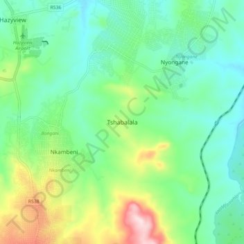
Name: Tshabalala topographic map, elevation, terrain.
Average elevation: 1,834 ft
Minimum elevation: 1,476 ft
Maximum elevation: 2,740 ft
Other topographic maps
Click on a map to view its topography, its elevation and its terrain.
Kanyamazane
South Africa > Mpumalanga > Ehlanzeni District Municipality > Mbombela
Average elevation: 2,090 ft
Klipkoppie Dam
South Africa > Mpumalanga > Ehlanzeni District Municipality > Mbombela
Average elevation: 3,192 ft
Tekwane North
South Africa > Mpumalanga > Ehlanzeni District Municipality > Mbombela
Average elevation: 2,530 ft
Tekwane North
South Africa > Mpumalanga > Ehlanzeni District Municipality > Mbombela > eMankayana
Average elevation: 2,530 ft
Kanyamazane
South Africa > Mpumalanga > Ehlanzeni District Municipality > Mbombela
Average elevation: 2,087 ft
Longmere Dam
South Africa > Mpumalanga > Ehlanzeni District Municipality > Mbombela > White River Country Estates
Average elevation: 3,159 ft