Geolocate

Jerome topographic map

Click on the map to display elevation.

About this map

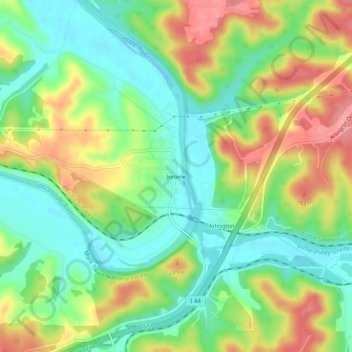
Name: Jerome topographic map, elevation, terrain.

Location: Jerome, Phelps County, Missouri, 65529, United States (37.90615 -91.99766 37.94615 -91.95766)

Average elevation: 797 ft

Minimum elevation: 653 ft

Maximum elevation: 1,007 ft

Phelps County trails, hiking, mountain biking, running and outdoor activities

Other topographic maps

Click on a map to view its topography, its elevation and its terrain.

Rolla

United States > Missouri > Phelps County

Average elevation: 1,017 ft

Edgar Springs

United States > Missouri > Phelps County

Average elevation: 1,178 ft

Rolla

United States > Missouri > Phelps County

Average elevation: 1,017 ft

Rolla

United States > Missouri > Phelps County

Average elevation: 1,017 ft

Rolla

United States > Missouri > Phelps County

Average elevation: 1,017 ft

Gear up for your next adventure:

🦟Ultrasonic Repellers - Create a bug-free zone at your camp or rest stop
📶Vehicle Signal Boosters - Improve reception in rural areas while driving to trailheads
🛰️Satellite Messengers - Emergency SOS and two-way messaging for off-grid adventures
Backpacking Tent - Lightweight and durable tent for multi‑day hikes
🏕️Family Camping Gear - Essentials for group camping trips

As an Amazon Associate, this site earns from qualifying purchases at no extra cost to you.