
Bethioua topographic map
Interactive map
Click on the map to display elevation.
About this map
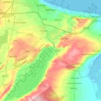
Name: Bethioua topographic map, elevation, terrain.
Location: Bethioua, Daïra Bethioua, Oran, Algérie (35.65256 -0.36318 35.82204 -0.19304)
Average elevation: 272 ft
Minimum elevation: -10 ft
Maximum elevation: 702 ft
Thomas Shaw visite les lieux en 1747 , y faisant une description géographique et topographique des ruines romaines.
Other topographic maps
Click on a map to view its topography, its elevation and its terrain.
Chehairia
Algérie > Oran > Daïra Bethioua > Aïn El Bia > Chehairia
Chehairia, Aïn El Bia, Daïra Bethioua, Oran, Algérie
Average elevation: 269 ft
Aïn El Bia
Algérie > Oran > Daïra Bethioua
Aïn El Bia, Daïra Bethioua, Oran, Algérie
Average elevation: 253 ft