
Aïn El Bia topographic map
Interactive map
Click on the map to display elevation.
About this map
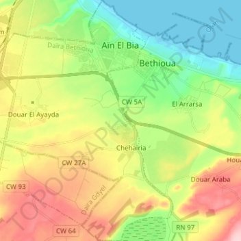
Name: Aïn El Bia topographic map, elevation, terrain.
Location: Aïn El Bia, Daïra Bethioua, Oran, Algérie (35.73143 -0.36177 35.83203 -0.25997)
Average elevation: 253 ft
Minimum elevation: -10 ft
Maximum elevation: 617 ft
Other topographic maps
Click on a map to view its topography, its elevation and its terrain.
Chehairia
Algérie > Oran > Daïra Bethioua > Aïn El Bia > Chehairia
Chehairia, Aïn El Bia, Daïra Bethioua, Oran, Algérie
Average elevation: 269 ft
Bethioua
Algérie > Oran > Daïra Bethioua
Bethioua, Daïra Bethioua, Oran, Algérie
Average elevation: 272 ft