Geolocate

Derby topographic map

Click on the map to display elevation.

About this map

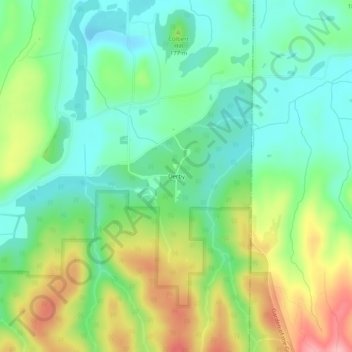
Name: Derby topographic map, elevation, terrain.

Location: Derby, Saline County, Illinois, 62947, United States (37.60894 -88.40560 37.64894 -88.36560)

Average elevation: 509 ft

Minimum elevation: 351 ft

Maximum elevation: 797 ft

Saline County trails, hiking, mountain biking, running and outdoor activities

Other topographic maps

Click on a map to view its topography, its elevation and its terrain.

Raleigh

United States > Illinois > Saline County

Average elevation: 423 ft

Galatia

United States > Illinois > Saline County

Average elevation: 423 ft

Eldorado

United States > Illinois > Saline County

Average elevation: 410 ft

Carrier Mills

United States > Illinois > Saline County

Average elevation: 404 ft

Muddy

United States > Illinois > Saline County

Average elevation: 364 ft

Stonefort

United States > Illinois > Saline County

Average elevation: 433 ft

Gear up for your next adventure:

🪶Survival Guide Book - Expert advice for emergency preparedness
Backpacking Tent - Lightweight and durable tent for multi‑day hikes
🕶️Glacier Sunglasses - Side shields to protect eyes from high-altitude snow glare
🔋Rechargeable Batteries - Power up your outdoor devices
🌎3D Topographic Globes - Raised relief globes for a tactile understanding of geography

As an Amazon Associate, this site earns from qualifying purchases at no extra cost to you.