
Thank you for supporting this site ❤️
Make a donation
Make a donation
Gear up for your next adventure:
As an Amazon Associate, this site earns from qualifying purchases at no extra cost to you.
Azinhal, Peva e Valverde topographic map
Click on the map to display elevation.
Thank you for supporting this site ❤️
Make a donation
Make a donation
Gear up for your next adventure:
As an Amazon Associate, this site earns from qualifying purchases at no extra cost to you.
About this map
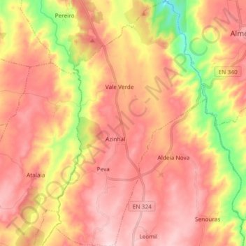
Name: Azinhal, Peva e Valverde topographic map, elevation, terrain.
Location: Azinhal, Peva e Valverde, Almeida, Guarda, Portugal (40.63021 -7.01972 40.74105 -6.92945)
Average elevation: 2,221 ft
Minimum elevation: 1,631 ft
Maximum elevation: 2,605 ft
Thank you for supporting this site ❤️
Make a donation
Make a donation
Gear up for your next adventure:
As an Amazon Associate, this site earns from qualifying purchases at no extra cost to you.
Other topographic maps
Click on a map to view its topography, its elevation and its terrain.