
Thank you for supporting this site ❤️
Make a donation
Make a donation
Gear up for your next adventure:
As an Amazon Associate, this site earns from qualifying purchases at no extra cost to you.
Monteperobolso topographic map
Click on the map to display elevation.
Thank you for supporting this site ❤️
Make a donation
Make a donation
Gear up for your next adventure:
As an Amazon Associate, this site earns from qualifying purchases at no extra cost to you.
About this map
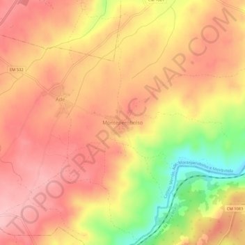
Name: Monteperobolso topographic map, elevation, terrain.
Location: Monteperobolso, Almeida, Guarda, 6355-030, Portugal (40.53426 -6.99999 40.57426 -6.95999)
Average elevation: 2,546 ft
Minimum elevation: 2,198 ft
Maximum elevation: 2,733 ft
Thank you for supporting this site ❤️
Make a donation
Make a donation
Gear up for your next adventure:
As an Amazon Associate, this site earns from qualifying purchases at no extra cost to you.
Other topographic maps
Click on a map to view its topography, its elevation and its terrain.