Geolocate

Western topographic map

Click on the map to display elevation.

About this map

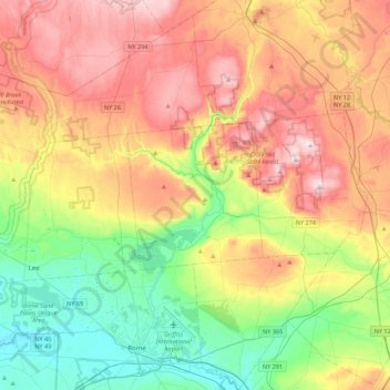
Name: Western topographic map, elevation, terrain.

Location: Western, Oneida County, New York, 13486, United States (43.17807 -75.54969 43.49807 -75.22969)

Average elevation: 1,007 ft

Minimum elevation: 381 ft

Maximum elevation: 1,814 ft

Oneida County trails, hiking, mountain biking, running and outdoor activities

Other topographic maps

Click on a map to view its topography, its elevation and its terrain.

Town of Annsville

United States > New York > Oneida County

Average elevation: 896 ft

Village of Boonville

United States > New York > Oneida County

Average elevation: 1,161 ft

Washington Mills

United States > New York > Oneida County

Average elevation: 771 ft

Village of Camden

United States > New York > Oneida County

Average elevation: 551 ft

Town of Kirkland

United States > New York > Oneida County

Average elevation: 846 ft

Town of Lee

United States > New York > Oneida County

Average elevation: 810 ft

Town of Steuben

United States > New York > Oneida County

Average elevation: 1,224 ft

Town of Deerfield

United States > New York > Oneida County

Average elevation: 938 ft

White Lake

United States > New York > Oneida County

Average elevation: 1,470 ft

Gear up for your next adventure:

🏔️Mountain Trail Maps - High‑detail maps for popular peaks
🥾Hiking Shoes - Durable and comfortable shoes for trail hiking
🛰️Satellite Messengers - Emergency SOS and two-way messaging for off-grid adventures
🪑Ultralight Camp Chairs - Portable seating for resting after a long day of mapping
🧺Microfiber Travel Towels - Compact and fast-drying towels for trail use

As an Amazon Associate, this site earns from qualifying purchases at no extra cost to you.