Geolocate

Washington Mills topographic map

Click on the map to display elevation.

About this map

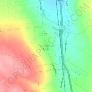
Name: Washington Mills topographic map, elevation, terrain.

Location: Washington Mills, Town of New Hartford, Oneida County, New York, United States (43.03948 -75.29427 43.05701 -75.27194)

Average elevation: 771 ft

Minimum elevation: 568 ft

Maximum elevation: 1,020 ft

Oneida County trails, hiking, mountain biking, running and outdoor activities

Other topographic maps

Click on a map to view its topography, its elevation and its terrain.

Air City

United States > New York > Oneida County > City of Rome

Average elevation: 472 ft

McConnellsville

United States > New York > Oneida County

Average elevation: 531 ft

Brookfield

United States > New York > Oneida County > Town of Lee

Average elevation: 659 ft

Sauquoit

United States > New York > Oneida County > Town of Paris

Average elevation: 1,014 ft

White Lake

United States > New York > Oneida County

Average elevation: 1,470 ft

Stittville

United States > New York > Oneida County > Stittville

Average elevation: 597 ft

Westdale

United States > New York > Oneida County > Westdale

Average elevation: 627 ft

Cassville

United States > New York > Oneida County > Town of Paris > Cassville

Average elevation: 1,358 ft

Western

United States > New York > Oneida County

Average elevation: 1,007 ft

Gear up for your next adventure:

🌐World Map Poster - Decorative world maps with topographic info
🌡️Handheld Weather Meters - Measure wind, temp, and pressure for safe mountain travel
🪶LED Camping Lantern - Bright lantern for camp lighting
🥾Men's Hiking Boots - Durable, waterproof footwear for rugged terrain and steep inclines
👟Trail Running Shoes - Lightweight shoes for trail runners

As an Amazon Associate, this site earns from qualifying purchases at no extra cost to you.