
Make a donation
Gear up for your next adventure:
As an Amazon Associate, this site earns from qualifying purchases at no extra cost to you.
Waterton Park topographic map
Click on the map to display elevation.
Make a donation
Gear up for your next adventure:
As an Amazon Associate, this site earns from qualifying purchases at no extra cost to you.
Waterton Park
It is located at the southwestern terminus of Highway 5, approximately 54 kilometres (34 mi) west of the Town of Cardston and 55 kilometres (34 mi) south of the Town of Pincher Creek. This hamlet is north of Glacier National Park in Montana. It has an elevation of 1,280 metres (4,200 ft).
Make a donation
Gear up for your next adventure:
As an Amazon Associate, this site earns from qualifying purchases at no extra cost to you.
About this map
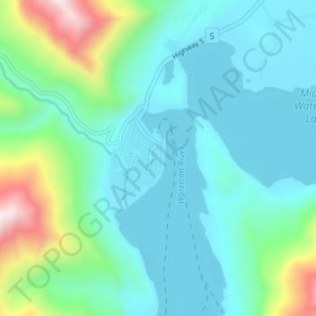
Name: Waterton Park topographic map, elevation, terrain.
Average elevation: 4,777 ft
Minimum elevation: 4,163 ft
Maximum elevation: 7,241 ft
Make a donation
Gear up for your next adventure:
As an Amazon Associate, this site earns from qualifying purchases at no extra cost to you.
Other topographic maps
Click on a map to view its topography, its elevation and its terrain.
Waterton Lakes National Park
Canada > Alberta > Improvement District No. 04
Operated by Parks Canada, Waterton is open all year, but the main tourist season is during July and August. The only commercial facilities available within the park are located at the Waterton Park townsite. This park ranges in elevation from 1,290 metres (4,232 ft) at the townsite to 2,910 m (9,547 ft) at…
Average elevation: 5,833 ft