Geolocate

Karur topographic map

Click on the map to display elevation.

Karur

Karur is located at 10°57′36″N 78°04′30″E / 10.960°N 78.075°E / 10.960; 78.075 and has an average elevation of 101 metres or 331 feet. The town is located in Karur district, at a distance of 370 km (230 mi) from Chennai. The town is located on the banks of the rivers Amaravathi, Kaveri and Noyyal with a plain topography. There are no notable mineral resources available in and around the town. The soil types are black and red that are conducive for common crops in the Cauvery delta.

Wikipedia (CC-BY-SA 3.0)

About this map

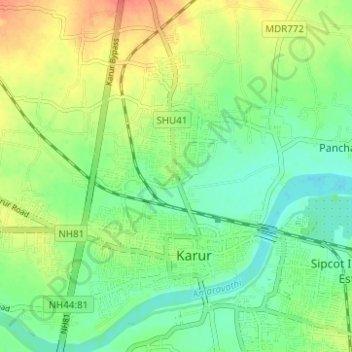
Name: Karur topographic map, elevation, terrain.

Location: Karur, Tamil Nadu, India (10.92235 78.02884 11.00011 78.11689)

Average elevation: 423 ft

Minimum elevation: 348 ft

Maximum elevation: 528 ft

Other topographic maps

Click on a map to view its topography, its elevation and its terrain.

Puliyur

India > Tamil Nadu > Karur

Average elevation: 381 ft

Vangal

India > Tamil Nadu > Karur

Average elevation: 400 ft

Thalavapalayam

India > Tamil Nadu > Karur

Average elevation: 413 ft

Periyar nagar

India > Tamil Nadu > Karur

Average elevation: 486 ft

Nanjai Pugalur

India > Tamil Nadu > Karur

Average elevation: 509 ft

Velayuthampalayam

India > Tamil Nadu > Karur

Average elevation: 453 ft

Pugalur

India > Tamil Nadu > Karur

Average elevation: 440 ft

Gear up for your next adventure:

🧦Hiking Socks - Comfortable socks to prevent blisters on long hikes
🛰️Handheld GPS Units - Professional satellite navigators for precise backcountry mapping
🗃️Trail First Aid Kit - Essential kit for outdoor injuries and emergencies
Solar GPS Watches - Advanced multisport watches with built-in topographic maps
🩹Survival Bandages - High‑quality bandages for emergencies

As an Amazon Associate, this site earns from qualifying purchases at no extra cost to you.