
Make a donation
Gear up for your next adventure:
As an Amazon Associate, this site earns from qualifying purchases at no extra cost to you.
Hohenstiege topographic map
Click on the map to display elevation.
Make a donation
Gear up for your next adventure:
As an Amazon Associate, this site earns from qualifying purchases at no extra cost to you.
About this map
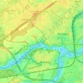
Name: Hohenstiege topographic map, elevation, terrain.
Average elevation: 46 ft
Minimum elevation: -7 ft
Maximum elevation: 82 ft
Make a donation
Gear up for your next adventure:
As an Amazon Associate, this site earns from qualifying purchases at no extra cost to you.
Other topographic maps
Click on a map to view its topography, its elevation and its terrain.
Travemünde
Deutschland > Schleswig-Holstein > Lübeck
Die Strandpromenade entlang der Ostsee mit einem breiten Sandstrand entstand von 1898 bis 1899 und wurde 1904 eingeweiht. Die besondere Atmosphäre ergibt sich durch die großzügigen Dimensionen und den Blick auf den Badebetrieb und den internationalen Fährverkehr. Von Ende 2010 bis Mitte 2012 wurde die…
Average elevation: 33 ft
Make a donation
Gear up for your next adventure:
As an Amazon Associate, this site earns from qualifying purchases at no extra cost to you.
Make a donation
Gear up for your next adventure:
As an Amazon Associate, this site earns from qualifying purchases at no extra cost to you.
Make a donation
Gear up for your next adventure:
As an Amazon Associate, this site earns from qualifying purchases at no extra cost to you.
Travemünde
Deutschland > Schleswig-Holstein > Lübeck
Die Strandpromenade entlang der Ostsee mit einem breiten Sandstrand entstand von 1898 bis 1899 und wurde 1904 eingeweiht. Die besondere Atmosphäre ergibt sich durch die großzügigen Dimensionen und den Blick auf den Badebetrieb und den internationalen Fährverkehr. Von Ende 2010 bis Mitte 2012 wurde die…
Average elevation: 33 ft