
Make a donation
Gear up for your next adventure:
As an Amazon Associate, this site earns from qualifying purchases at no extra cost to you.
Innenstadt topographic map
Click on the map to display elevation.
Make a donation
Gear up for your next adventure:
As an Amazon Associate, this site earns from qualifying purchases at no extra cost to you.
About this map
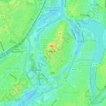
Name: Innenstadt topographic map, elevation, terrain.
Location: Innenstadt, Lübeck, Schleswig-Holstein, 23552, Deutschland (53.85546 10.67510 53.87648 10.69720)
Average elevation: 33 ft
Minimum elevation: -10 ft
Maximum elevation: 95 ft
Make a donation
Gear up for your next adventure:
As an Amazon Associate, this site earns from qualifying purchases at no extra cost to you.
Other topographic maps
Click on a map to view its topography, its elevation and its terrain.
Lübeck
Deutschland > Schleswig-Holstein > Lübeck
Die Stadt liegt in der Norddeutschen Tiefebene an der unteren Trave, einem schiffbaren Fluss, der etwa 17 Kilometer von der Altstadt entfernt im Stadtteil Travemünde in die Ostsee mündet. Die Altstadt liegt auf einem Hügel, der einen Werder zwischen den Wasserläufen der Trave und der Wakenitz bildet.…
Average elevation: 95 ft
Israelsdorf
Deutschland > Schleswig-Holstein > Lübeck
In dem topografischen Werk Die freie und Hansestadt Lübeck aus dem Jahr 1890 sind Angaben gegeben über Israelsdorf und die Geschichte des Dorfes, dessen der Stadt gehörige Feldmark schließlich 1781 in Erbpacht gelegt wurde. Dem Protocollum derer Memorialien und Votorum der vier großen und sämbtlichen…
Average elevation: 23 ft
Make a donation
Gear up for your next adventure:
As an Amazon Associate, this site earns from qualifying purchases at no extra cost to you.
Make a donation
Gear up for your next adventure:
As an Amazon Associate, this site earns from qualifying purchases at no extra cost to you.
Make a donation
Gear up for your next adventure:
As an Amazon Associate, this site earns from qualifying purchases at no extra cost to you.