Mount Airy topographic map
Interactive map
Click on the map to display elevation.
About this map
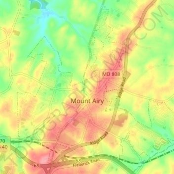
Name: Mount Airy topographic map, elevation, terrain.
Location: Mount Airy, Carroll County, Maryland, 21771, United States (39.35936 -77.17936 39.40122 -77.11890)
Average elevation: 725 ft
Minimum elevation: 554 ft
Maximum elevation: 883 ft
The town was originally settled in the early 1830s by a core group of six families. Dorsey, Davis and Bussard were the most prominent names in that first settlement, which was followed closely by the construction of the B & O railroad line in 1831. Because Mount Airy sits at an elevation of 830 feet (250 m), a series of four inclined planes were constructed in order for the trains to climb the steep hills. Locomotives and cars were lifted with the assistance of horses and steam winches. Passengers had to disembark during this process. Plane #4, located west of the town at the intersection of Woodville Road and MD Route 144, is still a recognized location today. In 1839 the planes were abandoned, and the new line was constructed north of where Mount Airy is today. This was a result of more powerful locomotives that had been constructed and heavier loads were being hauled. In 1901, a railroad tunnel was constructed on the south side of town and the existing line into town became a spur line into the center of Mount Airy. The town named the first resident, Henry Bussard, the station agent for the new train station. Mr. Bussard was the first major landowner in Mount Airy.
Other topographic maps
Click on a map to view its topography, its elevation and its terrain.
Bear Branch
United States > Maryland > Carroll County > Brown Heights
Bear Branch, Brown Heights, Carroll County, Maryland, United States
Average elevation: 476 ft
Belle Grove Square
United States > Maryland > Carroll County > Westminster
Belle Grove Square, Westminster, Carroll County, Maryland, 21157, United States
Average elevation: 735 ft
Finksburg
United States > Maryland > Carroll County
Finksburg, Carroll County, Maryland, 21048, United States
Average elevation: 518 ft
Hampstead
United States > Maryland > Carroll County
Hampstead, Carroll County, Maryland, United States
Average elevation: 794 ft
New Windsor
United States > Maryland > Carroll County
New Windsor, Carroll County, Maryland, United States
Average elevation: 505 ft
Eldersburg
United States > Maryland > Carroll County
Eldersburg, Carroll County, Maryland, 21784, United States
Average elevation: 545 ft
Keymar
United States > Maryland > Carroll County
Keymar, Carroll County, Maryland, 21757, United States
Average elevation: 420 ft
Gaither
United States > Maryland > Carroll County
Gaither, Carroll County, Maryland, 21784, United States
Average elevation: 528 ft
Union Bridge
United States > Maryland > Carroll County
Union Bridge, Carroll County, Maryland, United States
Average elevation: 453 ft
Avondale Wildlife Management Area
United States > Maryland > Carroll County > Chapel Heights
Avondale Wildlife Management Area, Chapel Heights, Carroll County, Maryland, United States
Average elevation: 676 ft
Melrose
United States > Maryland > Carroll County
Melrose, Carroll County, Maryland, United States
Average elevation: 860 ft
Heritage
United States > Maryland > Carroll County
Heritage, Carroll County, Maryland, United States
Average elevation: 702 ft
Washington Heights
United States > Maryland > Carroll County > Westminster
Washington Heights, Westminster, Carroll County, Maryland, 21157, United States
Average elevation: 764 ft
Taneytown
United States > Maryland > Carroll County
Taneytown, Carroll County, Maryland, 21787, United States
Average elevation: 502 ft
Millers
United States > Maryland > Carroll County
Millers, Carroll County, Maryland, 21102, United States
Average elevation: 873 ft
Union Mills Homestead Park
United States > Maryland > Carroll County > Union Mills
Union Mills Homestead Park, Union Mills, Carroll County, Maryland, United States
Average elevation: 640 ft
Furnace Hills
United States > Maryland > Carroll County > Westminster
Furnace Hills, Westminster, Carroll County, Maryland, 21157, United States
Average elevation: 692 ft
Marston
United States > Maryland > Carroll County
Marston, Carroll County, Maryland, 21776, United States
Average elevation: 620 ft
Liberty Reservoir
United States > Maryland > Carroll County
Liberty Reservoir, Carroll County, Maryland, United States
Average elevation: 558 ft
Cape Horn South
United States > Maryland > Carroll County
Cape Horn South, Carroll County, Maryland, United States
Average elevation: 840 ft
Meadow Brook
United States > Maryland > Carroll County > Taneytown
Meadow Brook, Taneytown, Carroll County, Maryland, 21787, United States
Average elevation: 512 ft
Woodbine
United States > Maryland > Carroll County
Woodbine, Carroll County, Maryland, 21797, United States
Average elevation: 597 ft
Mill Stream Hills
United States > Maryland > Carroll County
Mill Stream Hills, Carroll County, Maryland, 21088, United States
Average elevation: 781 ft
Silver Run
United States > Maryland > Carroll County
Silver Run, Carroll County, Maryland, United States
Average elevation: 650 ft
Eldersburg
United States > Maryland > Carroll County > Eldersburg
Eldersburg, Carroll County, Maryland, 21784, United States
Average elevation: 548 ft
Forest Hills
United States > Maryland > Carroll County > Forest Hills
Forest Hills, Carroll County, Maryland, 21157, United States
Average elevation: 745 ft
Manchester
United States > Maryland > Carroll County
Manchester, Carroll County, Maryland, United States
Average elevation: 906 ft
Westminster
United States > Maryland > Carroll County
Westminster, Carroll County, Maryland, United States
Average elevation: 741 ft
Mount Airy
United States > Maryland > Carroll County > Mount Airy > Mount Airy
Mount Airy, Carroll County, Maryland, 21771, United States
Average elevation: 712 ft
Sykesville
United States > Maryland > Carroll County
Sykesville, Carroll County, Maryland, United States
Average elevation: 499 ft
Piney Creek
United States > Maryland > Carroll County
Piney Creek, Carroll County, Maryland, 21787, United States
Average elevation: 499 ft