
Make a donation
Gear up for your next adventure:
As an Amazon Associate, this site earns from qualifying purchases at no extra cost to you.
Linden Estates topographic map
Click on the map to display elevation.
Make a donation
Gear up for your next adventure:
As an Amazon Associate, this site earns from qualifying purchases at no extra cost to you.
About this map
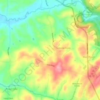
Name: Linden Estates topographic map, elevation, terrain.
Average elevation: 676 ft
Minimum elevation: 502 ft
Maximum elevation: 879 ft
Make a donation
Gear up for your next adventure:
As an Amazon Associate, this site earns from qualifying purchases at no extra cost to you.
Other topographic maps
Click on a map to view its topography, its elevation and its terrain.
Westminster
United States > Maryland > Carroll County
Westminster lies in the humid subtropical climate zone, with hot and humid summers and cool winters with highly variable seasonal snowfall. Due to its elevation, distance from the Chesapeake Bay and urban heat island, temperatures in Westminster are often considerably lower than in Baltimore, especially at…
Average elevation: 741 ft
Mount Airy
United States > Maryland > Carroll County
The town was originally settled in the early 1830s by a core group of six families. Dorsey, Davis and Bussard were the most prominent names in that first settlement, which was followed closely by the construction of the B & O railroad line in 1831. Because Mount Airy sits at an elevation of 830 feet (250 m), a…
Average elevation: 725 ft
Make a donation
Gear up for your next adventure:
As an Amazon Associate, this site earns from qualifying purchases at no extra cost to you.
Make a donation
Gear up for your next adventure:
As an Amazon Associate, this site earns from qualifying purchases at no extra cost to you.
Mount Airy
United States > Maryland > Carroll County
The town was originally settled in the early 1830s by a core group of six families. Dorsey, Davis and Bussard were the most prominent names in that first settlement, which was followed closely by the construction of the B & O railroad line in 1831. Because Mount Airy sits at an elevation of 830 feet (250 m), a…
Average elevation: 725 ft
Make a donation
Gear up for your next adventure:
As an Amazon Associate, this site earns from qualifying purchases at no extra cost to you.
Westminster
United States > Maryland > Carroll County
Westminster lies in the humid subtropical climate zone bordering on a humid continental climate, with hot and humid summers and cool winters with highly variable seasonal snowfall. Due to its elevation, distance from the Chesapeake Bay and urban heat island, temperatures in Westminster are often considerably…
Average elevation: 748 ft