
Kalihiwai topographic map
Interactive map
Click on the map to display elevation.
About this map
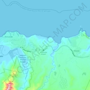
Name: Kalihiwai topographic map, elevation, terrain.
Location: Kalihiwai, Kauaʻi County, Hawaii, United States (22.19283 -159.47169 22.23687 -159.36885)
Average elevation: 220 ft
Minimum elevation: 0 ft
Maximum elevation: 2,323 ft
Other topographic maps
Click on a map to view its topography, its elevation and its terrain.
Kauai
United States > Hawaii > Kauaʻi County
Kauai, Kauaʻi County, Hawaii, United States
Average elevation: 709 ft
Tunnels Beach
United States > Hawaii > Kauaʻi County > Haena
Tunnels Beach, Haena, Kauaʻi County, Hawaii, United States
Average elevation: 203 ft
Princeville
United States > Hawaii > Kauaʻi County
Princeville, Kauaʻi County, Hawaii, 96722, United States
Average elevation: 69 ft
Omao
United States > Hawaii > Kauaʻi County
Omao, Kauaʻi County, Hawaii, 96765, United States
Average elevation: 564 ft
Puuwai
United States > Hawaii > Kauaʻi County
Puuwai, Kauaʻi County, Hawaii, United States
Average elevation: 39 ft
Moloaʻa Bay
United States > Hawaii > Kauaʻi County
Moloaʻa Bay, Kauaʻi County, Hawaii, 96702, United States
Average elevation: 102 ft
Waimea River
United States > Hawaii > Kauaʻi County
Waimea River, Kauaʻi County, Hawaii, United States
Average elevation: 1,581 ft
Hanalei River
United States > Hawaii > Kauaʻi County > Hanalei
Hanalei River, Hanalei, Kauaʻi County, Hawaii, 96722, United States
Average elevation: 1,421 ft
Hanalei
United States > Hawaii > Kauaʻi County
Hanalei, Kauaʻi County, Hawaii, 96714, United States
Average elevation: 361 ft
Lawai
United States > Hawaii > Kauaʻi County > Lawai
Lawai, Kauaʻi County, Hawaii, 96765, United States
Average elevation: 584 ft
Kilauea
United States > Hawaii > Kauaʻi County
Kilauea, Kauaʻi County, Hawaii, 96754, United States
Average elevation: 292 ft
Kalaheo
United States > Hawaii > Kauaʻi County
Kalaheo, Kauaʻi County, Hawaii, 96741, United States
Average elevation: 600 ft
Niihau
United States > Hawaii > Kauaʻi County > Puuwai
Niihau, Puuwai, Kauaʻi County, Hawaii, United States
Average elevation: 75 ft
Kapaa
United States > Hawaii > Kauaʻi County
Kapaa, Kauaʻi County, Hawaii, United States
Average elevation: 315 ft
Alaka‘i Swamp
United States > Hawaii > Kauaʻi County
Alaka‘i Swamp, Kauaʻi County, Hawaii, United States
Average elevation: 2,949 ft
Kalihiwai Reservoir
United States > Hawaii > Kauaʻi County
Kalihiwai Reservoir, Kauaʻi County, Hawaii, United States
Average elevation: 400 ft
Puhi
United States > Hawaii > Kauaʻi County > Puhi
Puhi, Kauaʻi County, Hawaii, United States
Average elevation: 374 ft
Hanalei Valley Lookout
United States > Hawaii > Kauaʻi County > Hanalei
Hanalei Valley Lookout, Kuhio Highway, Hanalei, Kauaʻi County, Hawaii, 96722, United States
Average elevation: 118 ft
Waimea Canyon State Park
United States > Hawaii > Kauaʻi County
Waimea Canyon State Park, Kauaʻi County, Hawaii, United States
Average elevation: 2,280 ft
Wailua
United States > Hawaii > Kauaʻi County > Wailua
Wailua, Kauaʻi County, Hawaii, United States
Average elevation: 128 ft
Poipu
United States > Hawaii > Kauaʻi County > Poipu
Poipu, Kauaʻi County, Hawaii, 96756, United States
Average elevation: 59 ft
Kekaha
United States > Hawaii > Kauaʻi County
Kekaha, Kauaʻi County, Hawaii, 96752, United States
Average elevation: 59 ft
Waimea
United States > Hawaii > Kauaʻi County > Waimea
Waimea, Kauaʻi County, Hawaii, United States
Average elevation: 194 ft
Koloa
United States > Hawaii > Kauaʻi County
Koloa, Kauaʻi County, Hawaii, 96756, United States
Average elevation: 233 ft
Ka Loko Reservoir
United States > Hawaii > Kauaʻi County
Ka Loko Reservoir, Kauaʻi County, Hawaii, United States
Average elevation: 705 ft
Wai‘ale‘ale
United States > Hawaii > Kauaʻi County
Wai‘ale‘ale, Kauaʻi County, Hawaii, United States
Average elevation: 4,173 ft
Hanapepe
United States > Hawaii > Kauaʻi County
Hanapepe, Kauaʻi County, Hawaii, 96709, United States
Average elevation: 144 ft
Lihue
United States > Hawaii > Kauaʻi County
Lihue, Kauaʻi County, Hawaii, 96766, United States
Average elevation: 226 ft