
Hanalei topographic map
Click on the map to display elevation.
About this map
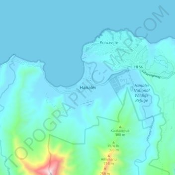
Name: Hanalei topographic map, elevation, terrain.
Location: Hanalei, Kauaʻi County, Hawaii, 96714, United States (22.16299 -159.53569 22.24299 -159.45569)
Average elevation: 361 ft
Minimum elevation: 0 ft
Maximum elevation: 3,648 ft
Kauaʻi County trails, hiking, mountain biking, running and outdoor activities
Other topographic maps
Click on a map to view its topography, its elevation and its terrain.
Kauai
United States > Hawaii > Kauaʻi County
Kauaʻi's climate is tropical, with generally humid and stable conditions year-round, although weather phenomena and infrequent storms have caused instances of extreme weather. At the lower elevations, the annual precipitation varies from an average of about 50 in (130 cm) on the windward (northeastern) shore…
Average elevation: 709 ft
Kauai
United States > Hawaii > Kauaʻi County
Kauai, known as the "Garden Isle," features a remarkably diverse topography shaped by its volcanic origins and extensive erosion over millions of years. The island is characterized by a central mountainous region, dominated by the towering 5,148-foot Mount Waiʻaleʻale, one of the wettest places on Earth, and…
Average elevation: 709 ft
Niihau
United States > Hawaii > Kauaʻi County > Puuwai
Niʻihau is located about 18 miles (29 km) west of Kauaʻi, and the tiny, uninhabited island of Lehua lies 0.7 miles (0.61 nmi; 1.1 km) north of Niʻihau. Niʻihau's dimensions are 6.2 miles by 18.6 miles (10 km × 30 km). The maximum elevation (Paniau) is 1,280 feet (390 m). The island is about 6 million…
Average elevation: 75 ft
Niihau
United States > Hawaii > Kauaʻi County > Puuwai
Niʻihau is located about 18 miles (29 km) west of Kauaʻi, and the tiny, uninhabited island of Lehua lies 0.7 miles (0.61 nmi; 1.1 km) north of Niʻihau. Niʻihau's dimensions are 6.2 miles by 18.6 miles (10km × 30km). The maximum elevation (Paniau) is 1,280 feet (390 m). The island is about 6 million years…
Average elevation: 75 ft
Kauai
United States > Hawaii > Kauaʻi County
Kauaʻi's climate is tropical, with generally humid and stable conditions year-round, although weather phenomena and infrequent storms have caused instances of extreme weather. At the lower elevations, the annual precipitation varies from an average of about 50 in (130 cm) on the windward (northeastern) shore…
Average elevation: 709 ft
Kauai
United States > Hawaii > Kauaʻi County
Kauaʻi's climate is tropical, with generally humid and stable conditions year-round, although infrequent storms cause severe flooding. At the lower elevations, the annual precipitation varies from an average of about 50 in (130 cm) on the windward (northeastern) shore to less than 20 in (51 cm) on the…
Average elevation: 709 ft