
Make a donation
Gear up for your next adventure:
As an Amazon Associate, this site earns from qualifying purchases at no extra cost to you.
Umguza topographic map
Click on the map to display elevation.
Make a donation
Gear up for your next adventure:
As an Amazon Associate, this site earns from qualifying purchases at no extra cost to you.
About this map
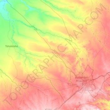
Name: Umguza topographic map, elevation, terrain.
Location: Umguza, Matabeleland North Province, Zimbabwe (-20.35534 27.75882 -19.36000 28.98388)
Average elevation: 3,996 ft
Minimum elevation: 3,245 ft
Maximum elevation: 5,013 ft
Make a donation
Gear up for your next adventure:
As an Amazon Associate, this site earns from qualifying purchases at no extra cost to you.
Other topographic maps
Click on a map to view its topography, its elevation and its terrain.
Hwange
Zimbabwe > Matabeleland North Province > Hwange
Hwange (formerly Wankie) is a town in Zimbabwe, located in Hwange District, in Matabeleland North Province, in northwestern Zimbabwe, close to the international borders with Botswana and Zambia. It lies approximately 100 kilometres (62 mi), by road, southeast of Victoria Falls, the nearest large city. The town…
Average elevation: 2,539 ft
Make a donation
Gear up for your next adventure:
As an Amazon Associate, this site earns from qualifying purchases at no extra cost to you.
Victoria Falls
Zimbabwe > Matabeleland North Province > Hwange > Victoria Falls Municipality
Average elevation: 3,012 ft
Victoria Falls
Zimbabwe > Matabeleland North Province > Hwange > Victoria Falls
Average elevation: 2,890 ft
Victoria Falls
Zimbabwe > Matabeleland North Province > Hwange > Victoria Falls
Average elevation: 2,890 ft
Make a donation
Gear up for your next adventure:
As an Amazon Associate, this site earns from qualifying purchases at no extra cost to you.
Devil's Cataract
Zimbabwe > Matabeleland North Province > Hwange > Victoria Falls
Average elevation: 2,900 ft