
Chilton topographic map
Click on the map to display elevation.
About this map
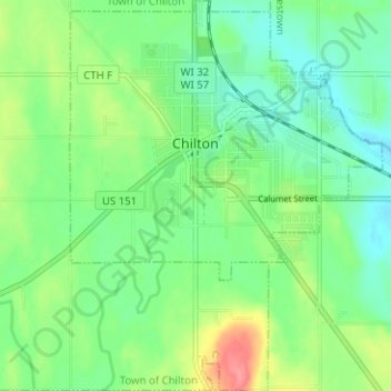
Name: Chilton topographic map, elevation, terrain.
Location: Chilton, Calumet County, Wisconsin, United States (44.00028 -88.18309 44.04547 -88.13269)
Average elevation: 902 ft
Minimum elevation: 827 ft
Maximum elevation: 1,053 ft
Calumet County trails, hiking, mountain biking, running and outdoor activities
Other topographic maps
Click on a map to view its topography, its elevation and its terrain.
Calumet County Park
United States > Wisconsin > Calumet County > Rockaway Beach
Average elevation: 843 ft