
Make a donation
Gear up for your next adventure:
As an Amazon Associate, this site earns from qualifying purchases at no extra cost to you.
Lake Pūkaki topographic map
Click on the map to display elevation.
Make a donation
Gear up for your next adventure:
As an Amazon Associate, this site earns from qualifying purchases at no extra cost to you.
Lake Pūkaki
The glacial feed to the lakes gives them a distinctive blue colour, created by glacial flour, the extremely finely ground rock particles from the glaciers. Lake Pukaki covers an area of 178.7 km2 (69.0 sq mi), and the surface elevation of the lake normally ranges from 518.2 to 532 metres (1,700 to 1,745 ft) above sea level.
Make a donation
Gear up for your next adventure:
As an Amazon Associate, this site earns from qualifying purchases at no extra cost to you.
About this map
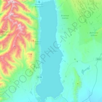
Name: Lake Pūkaki topographic map, elevation, terrain.
Location: Lake Pūkaki, Mackenzie District, Canterbury, New Zealand (-44.19050 170.11500 -43.90489 170.22307)
Average elevation: 2,907 ft
Minimum elevation: 1,660 ft
Maximum elevation: 8,179 ft
Make a donation
Gear up for your next adventure:
As an Amazon Associate, this site earns from qualifying purchases at no extra cost to you.
Other topographic maps
Click on a map to view its topography, its elevation and its terrain.
Mount Cook
New Zealand > Canterbury > Mackenzie District
Aoraki / Mount Cook is the highest mountain in New Zealand. Its height, as of 2014, is listed as 3,724 metres (12,218 feet). It sits in the Southern Alps, the mountain range that runs the length of the South Island. A popular tourist destination, it is also a favourite challenge for mountain climbers. Aoraki /…
Average elevation: 9,580 ft