
Make a donation
Gear up for your next adventure:
As an Amazon Associate, this site earns from qualifying purchases at no extra cost to you.
Hanson topographic map
Click on the map to display elevation.
Make a donation
Gear up for your next adventure:
As an Amazon Associate, this site earns from qualifying purchases at no extra cost to you.
Hanson
Mostly flatland, the highest elevation in town is Bonney Hill at 152 ft, making it one of the highest points in Plymouth County. Another hill of prominence is Almshouse Hill near the current day center of town and named for the Josiah Cushing home (built in 1763), which was purchased in 1837 and used as an almshouse until 1902.
Make a donation
Gear up for your next adventure:
As an Amazon Associate, this site earns from qualifying purchases at no extra cost to you.
About this map
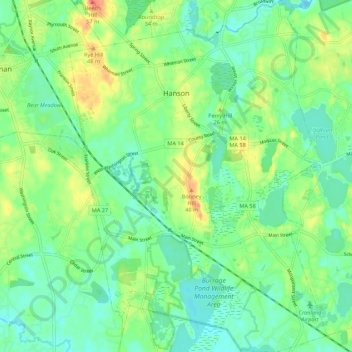
Name: Hanson topographic map, elevation, terrain.
Location: Hanson, Plymouth County, Massachusetts, United States (42.01572 -70.91296 42.09633 -70.83346)
Average elevation: 85 ft
Minimum elevation: 30 ft
Maximum elevation: 184 ft
Plymouth County trails, hiking, mountain biking, running and outdoor activities
Make a donation
Gear up for your next adventure:
As an Amazon Associate, this site earns from qualifying purchases at no extra cost to you.
Other topographic maps
Click on a map to view its topography, its elevation and its terrain.
West Meadow
United States > Massachusetts > Plymouth County > West Bridgewater
Average elevation: 95 ft
Make a donation
Gear up for your next adventure:
As an Amazon Associate, this site earns from qualifying purchases at no extra cost to you.
Miles Standish Park
United States > Massachusetts > Plymouth County > Duxbury
Average elevation: 49 ft
Make a donation
Gear up for your next adventure:
As an Amazon Associate, this site earns from qualifying purchases at no extra cost to you.
Kenberma
United States > Massachusetts > Plymouth County > Hull > Nantasket Beach
Average elevation: 7 ft
Marshfield Center
United States > Massachusetts > Plymouth County > Marshfield
Average elevation: 112 ft
Make a donation
Gear up for your next adventure:
As an Amazon Associate, this site earns from qualifying purchases at no extra cost to you.
Mill Pond
United States > Massachusetts > Plymouth County > Duxbury > Miles Standish Park
Average elevation: 66 ft
Eldon B. Kieth Field
United States > Massachusetts > Plymouth County > Brockton
Average elevation: 131 ft
Make a donation
Gear up for your next adventure:
As an Amazon Associate, this site earns from qualifying purchases at no extra cost to you.
Fresh Pond
United States > Massachusetts > Plymouth County > Plymouth > Cedar Bushes
Average elevation: 46 ft
Make a donation
Gear up for your next adventure:
As an Amazon Associate, this site earns from qualifying purchases at no extra cost to you.
Arthur Thurbur Land
United States > Massachusetts > Plymouth County > Duxbury > Baileys Corner
Average elevation: 59 ft
Scotland Estates
United States > Massachusetts > Plymouth County > Bridgewater
Average elevation: 92 ft
Make a donation
Gear up for your next adventure:
As an Amazon Associate, this site earns from qualifying purchases at no extra cost to you.
Peddocks Island
United States > Massachusetts > Plymouth County > Hull > Fort Andrews
Average elevation: 3 ft
Great Herring Pond
United States > Massachusetts > Plymouth County > Plymouth > Cedarville
Average elevation: 79 ft
Make a donation
Gear up for your next adventure:
As an Amazon Associate, this site earns from qualifying purchases at no extra cost to you.
Make a donation
Gear up for your next adventure:
As an Amazon Associate, this site earns from qualifying purchases at no extra cost to you.
Cedarville Landing
United States > Massachusetts > Plymouth County > Plymouth
Average elevation: 52 ft
Make a donation
Gear up for your next adventure:
As an Amazon Associate, this site earns from qualifying purchases at no extra cost to you.
Crescent Beach
United States > Massachusetts > Plymouth County > Mattapoisett
Average elevation: 16 ft
Make a donation
Gear up for your next adventure:
As an Amazon Associate, this site earns from qualifying purchases at no extra cost to you.
Make a donation
Gear up for your next adventure:
As an Amazon Associate, this site earns from qualifying purchases at no extra cost to you.
Green Harbor River
United States > Massachusetts > Plymouth County > Marshfield > Green Harbor
Average elevation: 7 ft
Kent Park
United States > Massachusetts > Plymouth County > Marshfield > Kent Park
Average elevation: 43 ft
Cranberry Village
United States > Massachusetts > Plymouth County > Carver > Cranberry Village
Average elevation: 98 ft
Indian Heights
United States > Massachusetts > Plymouth County > Wareham > Indian Heights
Average elevation: 26 ft
Make a donation
Gear up for your next adventure:
As an Amazon Associate, this site earns from qualifying purchases at no extra cost to you.
Marshfield Hills
United States > Massachusetts > Plymouth County > Marshfield > Marshfield Hills
Average elevation: 95 ft
Marshfield Hills
United States > Massachusetts > Plymouth County > Marshfield
Average elevation: 95 ft