
Thank you for supporting this site ❤️
Make a donation
Make a donation
Gear up for your next adventure:
As an Amazon Associate, this site earns from qualifying purchases at no extra cost to you.
Bise topographic map
Click on the map to display elevation.
Thank you for supporting this site ❤️
Make a donation
Make a donation
Gear up for your next adventure:
As an Amazon Associate, this site earns from qualifying purchases at no extra cost to you.
About this map
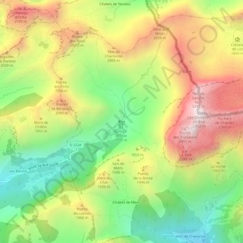
Name: Bise topographic map, elevation, terrain.
Average elevation: 5,801 ft
Minimum elevation: 4,045 ft
Maximum elevation: 7,854 ft
Thank you for supporting this site ❤️
Make a donation
Make a donation
Gear up for your next adventure:
As an Amazon Associate, this site earns from qualifying purchases at no extra cost to you.
Other topographic maps
Click on a map to view its topography, its elevation and its terrain.
Lac d'Arvouin
France > Auvergne-Rhône-Alpes > Haute-Savoie > La Chapelle-d'Abondance
Average elevation: 5,440 ft
Refuge de Trébentaz
France > Auvergne-Rhône-Alpes > Haute-Savoie > La Chapelle-d'Abondance > Le Clos
Average elevation: 5,709 ft