
Make a donation
Gear up for your next adventure:
As an Amazon Associate, this site earns from qualifying purchases at no extra cost to you.
Bath topographic map
Click on the map to display elevation.
Make a donation
Gear up for your next adventure:
As an Amazon Associate, this site earns from qualifying purchases at no extra cost to you.
Bath
Bath is also 100 miles (160 km) southwest of New York City and 60 miles (96 km) northwest of Philadelphia. It is also located near Wind Gap as well as the Delaware and Lehigh water gaps. Bath's elevation is 432 feet (132 m) above sea level as of 2011. The Borough is hilly and has many steep roads. There are two peaks in Bath, Hawk Mountain in the northeast, and Siegfried Hill in the southwest, which has been partially quarried out. Monocacy Creek, a tributary of the Lehigh River, flows through the town's center. The East Branch Monocacy also flows through Bath until their convergence further south. Other bodies of water include Penn-Dixie pond (the remains of a former quarry), the quarries at Keystone Cement, and numerous small ponds on the outskirts of town. Many mills operated using the flow of the Monocacy. Race and Mill street are named after them.
Make a donation
Gear up for your next adventure:
As an Amazon Associate, this site earns from qualifying purchases at no extra cost to you.
About this map
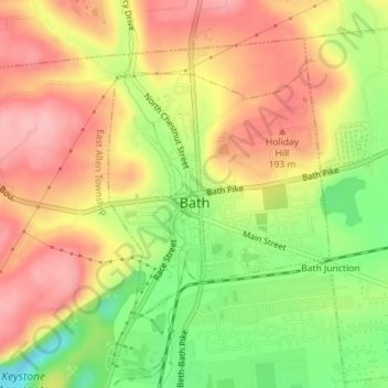
Name: Bath topographic map, elevation, terrain.
Location: Bath, Northampton County, Pennsylvania, United States (40.71836 -75.40142 40.73587 -75.38111)
Average elevation: 499 ft
Minimum elevation: 266 ft
Maximum elevation: 696 ft
Northampton County trails, hiking, mountain biking, running and outdoor activities
Make a donation
Gear up for your next adventure:
As an Amazon Associate, this site earns from qualifying purchases at no extra cost to you.
Other topographic maps
Click on a map to view its topography, its elevation and its terrain.
Mount Bethel
United States > Pennsylvania > Northampton County > Upper Mount Bethel Township
Average elevation: 512 ft
Danielsville
United States > Pennsylvania > Northampton County > Lehigh Township
Average elevation: 833 ft
Portlamd Waterfront Park
United States > Pennsylvania > Northampton County > Portland
Average elevation: 387 ft
Make a donation
Gear up for your next adventure:
As an Amazon Associate, this site earns from qualifying purchases at no extra cost to you.
Kreidersville
United States > Pennsylvania > Northampton County > Allen Township
Average elevation: 495 ft
Martins Creek
United States > Pennsylvania > Northampton County > Lower Mount Bethel Township
Average elevation: 417 ft
Morgan Hill
United States > Pennsylvania > Northampton County > Williams Township
Average elevation: 482 ft
Make a donation
Gear up for your next adventure:
As an Amazon Associate, this site earns from qualifying purchases at no extra cost to you.
Leithsville
United States > Pennsylvania > Northampton County > Lower Saucon Township
Average elevation: 531 ft
Brodhead
United States > Pennsylvania > Northampton County > Bethlehem Township
Average elevation: 377 ft
Mount Bethel
United States > Pennsylvania > Northampton County > Upper Mount Bethel Township
Average elevation: 512 ft
Illick's Mill Road Gateway
United States > Pennsylvania > Northampton County > Bethlehem
Average elevation: 344 ft
Make a donation
Gear up for your next adventure:
As an Amazon Associate, this site earns from qualifying purchases at no extra cost to you.
Martins Creek
United States > Pennsylvania > Northampton County > Lower Mount Bethel Township
Average elevation: 417 ft
West Bangor
United States > Pennsylvania > Northampton County > Washington Township
Average elevation: 1,017 ft
Moorestown
United States > Pennsylvania > Northampton County > Moore Township
Average elevation: 719 ft
Make a donation
Gear up for your next adventure:
As an Amazon Associate, this site earns from qualifying purchases at no extra cost to you.
Weaversville
United States > Pennsylvania > Northampton County > East Allen Township
Average elevation: 423 ft
Make a donation
Gear up for your next adventure:
As an Amazon Associate, this site earns from qualifying purchases at no extra cost to you.
Northwood Heights
United States > Pennsylvania > Northampton County > Palmer Township > Palmer Heights
Average elevation: 361 ft
Brodhead
United States > Pennsylvania > Northampton County > Bethlehem Township
Average elevation: 377 ft