
Make a donation
Gear up for your next adventure:
As an Amazon Associate, this site earns from qualifying purchases at no extra cost to you.
Hingene topographic map
Click on the map to display elevation.
Make a donation
Gear up for your next adventure:
As an Amazon Associate, this site earns from qualifying purchases at no extra cost to you.
Hingene
Hingene ligt nabij de Schelde. Langs deze rivier vindt men buitendijks schorrengebied en waterrijk polderland zoals de Oudbroekpolder en de Schellandpolder. Het domein van Kasteel d'Ursel is bosrijk. De hoogte bedraagt ongeveer 2 meter.
Make a donation
Gear up for your next adventure:
As an Amazon Associate, this site earns from qualifying purchases at no extra cost to you.
About this map
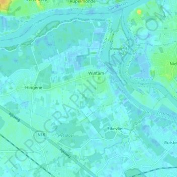
Name: Hingene topographic map, elevation, terrain.
Location: Hingene, Bornem, Mechelen, Antwerpen, België (51.08049 4.24911 51.12506 4.32826)
Average elevation: 10 ft
Minimum elevation: -10 ft
Maximum elevation: 75 ft
Make a donation
Gear up for your next adventure:
As an Amazon Associate, this site earns from qualifying purchases at no extra cost to you.
Other topographic maps
Click on a map to view its topography, its elevation and its terrain.
Buitenland
België > Antwerpen > Mechelen > Bornem
De enige boerderij die eind 18e eeuw in Buitenland stond, behoorde aan de familie Merckx. Philip Merckx (1778-1863) begon er met het telen van wissen en het vlechten van manden. In 1845 startte hij samen met Gaspar Broeckx een professionele mandenvlechterij: "De Compagnie". Frans Merckx (zoon van Philip en…
Average elevation: 20 ft