
Make a donation
Gear up for your next adventure:
As an Amazon Associate, this site earns from qualifying purchases at no extra cost to you.
Eikevliet topographic map
Click on the map to display elevation.
Make a donation
Gear up for your next adventure:
As an Amazon Associate, this site earns from qualifying purchases at no extra cost to you.
About this map
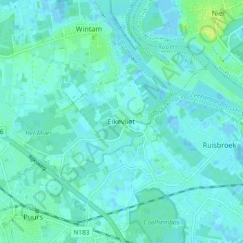
Name: Eikevliet topographic map, elevation, terrain.
Location: Eikevliet, Bornem, Mechelen, Antwerpen, 2870, België (51.07197 4.28485 51.11197 4.32485)
Average elevation: 10 ft
Minimum elevation: -13 ft
Maximum elevation: 43 ft
Make a donation
Gear up for your next adventure:
As an Amazon Associate, this site earns from qualifying purchases at no extra cost to you.
Other topographic maps
Click on a map to view its topography, its elevation and its terrain.
Hingene
België > Antwerpen > Mechelen > Bornem
Hingene ligt nabij de Schelde. Langs deze rivier vindt men buitendijks schorrengebied en waterrijk polderland zoals de Oudbroekpolder en de Schellandpolder. Het domein van Kasteel d'Ursel is bosrijk. De hoogte bedraagt ongeveer 2 meter.
Average elevation: 10 ft