Geolocate

Rockwall topographic map

Click on the map to display elevation.

About this map

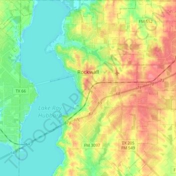
Name: Rockwall topographic map, elevation, terrain.

Location: Rockwall, Rockwall County, Texas, United States (32.85730 -96.48919 32.98245 -96.34975)

Average elevation: 512 ft

Minimum elevation: 430 ft

Maximum elevation: 627 ft

Rockwall County trails, hiking, mountain biking, running and outdoor activities

Other topographic maps

Click on a map to view its topography, its elevation and its terrain.

Heath

United States > Texas > Rockwall County > Heath > Heath

Average elevation: 486 ft

Gear up for your next adventure:

🧣Merino Neck Gaiters - Multi-functional headwear for wind and sun protection
🔦Compact Flashlight - Reliable flashlight for emergencies
📚USA Hiking Guide Books - Top trail guides and map books
🧢Sun Protection Hats - Wide-brimmed and UPF-rated hats for high-altitude sun safety
🥾Men's Hiking Boots - Durable, waterproof footwear for rugged terrain and steep inclines

As an Amazon Associate, this site earns from qualifying purchases at no extra cost to you.