
Mohrbach topographic map
Interactive map
Click on the map to display elevation.
About this map
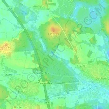
Name: Mohrbach topographic map, elevation, terrain.
Location: Mohrbach, Erlangen, Mittelfranken, Bayern, 91093, Deutschland (49.63072 10.91583 49.64059 10.93086)
Average elevation: 948 ft
Minimum elevation: 909 ft
Maximum elevation: 1,010 ft
Other topographic maps
Click on a map to view its topography, its elevation and its terrain.
Tennenlohe
Deutschland > Bayern > Erlangen
Tennenlohe, Erlangen, Bayern, 91058, Deutschland
Average elevation: 988 ft
Kriegenbrunn
Deutschland > Bayern > Erlangen
Kriegenbrunn, Erlangen, Bayern, 91056, Deutschland
Average elevation: 991 ft
Hüttendorf
Deutschland > Bayern > Erlangen
Hüttendorf, Erlangen, Bayern, 91058, Deutschland
Average elevation: 994 ft
Frauenaurach
Deutschland > Bayern > Erlangen > Frauenaurach
Frauenaurach, Erlangen, Bayern, 91056, Deutschland
Average elevation: 968 ft