
Anglesey topographic map
Interactive map
Click on the map to display elevation.
About this map
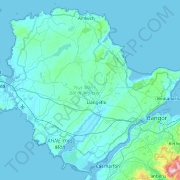
Name: Anglesey topographic map, elevation, terrain.
Location: Anglesey, Isle of Anglesey, Wales, United Kingdom (53.12635 -4.58862 53.43007 -4.04016)
Average elevation: 141 ft
Minimum elevation: -3 ft
Maximum elevation: 2,946 ft
Other topographic maps
Click on a map to view its topography, its elevation and its terrain.
South Stack Lighthouse
United Kingdom > Wales > Isle of Anglesey > Trearddur
South Stack Lighthouse, South Stack Road, Trearddur, Isle of Anglesey, Wales, LL65 1YH, United Kingdom
Average elevation: 56 ft
Cemaes
United Kingdom > Wales > Isle of Anglesey
Cemaes, Isle of Anglesey, Wales, LL67 0EY, United Kingdom
Average elevation: 66 ft
Cefn-bach
United Kingdom > Wales > Isle of Anglesey > Llanddaniel Fab
Cefn-bach, Llanddaniel Fab, Isle of Anglesey, Wales, LL61 6EQ, United Kingdom
Average elevation: 108 ft
Puffin Island
United Kingdom > Wales > Isle of Anglesey
Puffin Island, Isle of Anglesey, Wales, LL58 8RP, United Kingdom
Average elevation: 308 ft
Holyhead
United Kingdom > Wales > Isle of Anglesey > Holyhead
Holyhead, Isle of Anglesey, Wales, LL65 1UF, United Kingdom
Average elevation: 33 ft
Llanfairpwllgwyngyll
United Kingdom > Wales > Isle of Anglesey > Llanfairpwllgwyngyll
Llanfairpwllgwyngyll, Isle of Anglesey, Wales, LL61, United Kingdom
Average elevation: 138 ft