Geolocate

Paka topographic map

Click on the map to display elevation.

About this map

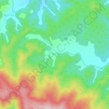
Name: Paka topographic map, elevation, terrain.

Location: Paka, Općina Čaglin, Požega-Slavonia County, Croatia (45.27020 18.03996 45.31020 18.07996)

Average elevation: 856 ft

Minimum elevation: 515 ft

Maximum elevation: 1,444 ft

Other topographic maps

Click on a map to view its topography, its elevation and its terrain.

Grad Požega

Croatia > Požega-Slavonia County

Požega (elevation: 152 m (499 ft)) is located in the south-western part of the Valley of Požega, or Požega basin, in Croatian: Požeška kotlina. This fertile valley has been important since the antiquity - its Roman name was Vallis Aurea, meaning "golden valley".

Average elevation: 728 ft

Gear up for your next adventure:

🛰️Satellite Messengers - Emergency SOS and two-way messaging for off-grid adventures
📦Gear Storage Bags - Organize and protect outdoor equipment
📻Weather Alert Radios - Stay informed of storm risks while off-the-grid
🏔️Mountain Trail Maps - High‑detail maps for popular peaks
🥘Titanium Cookware - Durable, featherlight pots and pans for backpacking

As an Amazon Associate, this site earns from qualifying purchases at no extra cost to you.