
Kalchreuth topographic map
Click on the map to display elevation.
Kalchreuth
Die Gemeinde liegt jeweils ca. zehn Kilometer nordöstlich von Nürnberg und südöstlich von Erlangen, im Erlanger Oberland, auf einem Höhenrücken des Sebalder Reichswalds. Der Ort wird wegen der zahlreichen Kirschbäume auch das Kirschendorf genannt. Kalchreuth liegt auf einem langgestreckten Höhenzug des Schwarzen Jura (Lias), der einen Teil des fränkischen Schichtstufenlandes bildet. Der Kalchreuther Forst westlich und südlich der Ortschaft ist ein beliebtes Ausflugsgebiet.
About this map
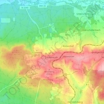
Name: Kalchreuth topographic map, elevation, terrain.
Location: Kalchreuth, Landkreis Erlangen-Höchstadt, Bayern, Deutschland (49.53200 11.09323 49.59056 11.16264)
Average elevation: 1,161 ft
Minimum elevation: 958 ft
Maximum elevation: 1,414 ft
Other topographic maps
Click on a map to view its topography, its elevation and its terrain.
Adlitz
Deutschland > Bayern > Landkreis Erlangen-Höchstadt
Das Dorf liegt am nördlichen Hang des Höhenzuges von Rathsberg nach Marloffstein. Unmittelbar ist der Ort von Acker- und Grünland umgeben. Etwas weiter westlich und östlich befinden sich Waldgebiete, das östliche wird Bergholz genannt. Durch diese Waldgebiete fließen zwei namenlose Bäche, die in…
Average elevation: 1,089 ft
Büg
Deutschland > Bayern > Landkreis Erlangen-Höchstadt > Eckental > Forth
Average elevation: 1,119 ft
Hauptendorf
Deutschland > Bayern > Landkreis Erlangen-Höchstadt > Herzogenaurach
Average elevation: 1,050 ft
Oberschöllenbach
Deutschland > Bayern > Landkreis Erlangen-Höchstadt > Eckental
Average elevation: 1,145 ft
Eckental
Deutschland > Bayern > Landkreis Erlangen-Höchstadt > Eckental > Eckental
Average elevation: 1,184 ft
Höchstadt an der Aisch
Deutschland > Bayern > Landkreis Erlangen-Höchstadt > Höchstadt a.d.Aisch > Höchstadt an der Aisch
Average elevation: 971 ft
Lappach
Deutschland > Bayern > Landkreis Erlangen-Höchstadt > Höchstadt a.d.Aisch
Average elevation: 958 ft
Zweifelsheim
Deutschland > Bayern > Landkreis Erlangen-Höchstadt > Herzogenaurach
Average elevation: 1,188 ft
Zentbechhofen
Deutschland > Bayern > Landkreis Erlangen-Höchstadt > Höchstadt an der Aisch
Average elevation: 994 ft
Rathsberg
Deutschland > Bayern > Landkreis Erlangen-Höchstadt
Der Ort und das gleichnamige Schloss Rathsberg liegen auf dem höchsten, westlichen Punkt des gleichnamigen Höhenzugs Rathsberg nordöstlich von Erlangen.
Average elevation: 1,007 ft
Beutelsdorf
Deutschland > Bayern > Landkreis Erlangen-Höchstadt > Herzogenaurach
Average elevation: 1,070 ft
Herzogenaurach
Deutschland > Bayern > Landkreis Erlangen-Höchstadt > Herzogenaurach
Average elevation: 1,079 ft
Atzelsberg
Deutschland > Bayern > Landkreis Erlangen-Höchstadt > Atzelsberg
Average elevation: 1,050 ft
Jungenhofen
Deutschland > Bayern > Landkreis Erlangen-Höchstadt > Höchstadt a.d.Aisch
Average elevation: 994 ft
Burgstall
Deutschland > Bayern > Landkreis Erlangen-Höchstadt > Herzogenaurach
Average elevation: 1,099 ft
Kleinseebach
Deutschland > Bayern > Landkreis Erlangen-Höchstadt > Kleinseebach
Average elevation: 932 ft